Alpy Berneńskie
 Finsteraarhorn i jego otoczenie | |
| Kontynent | |
|---|---|
| Państwo | |
| Najwyższy szczyt | Finsteraarhorn |
| Jednostka dominująca | |
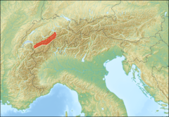
 Położenie na mapie Alp; granice pasma wg SOIUSA | |
| 46°32′N 8°03′E/46,533333 8,050000 | |


Alpy Berneńskie[1] (niem. Berner Alpen[1], fr. Alpes bernoises[1]) – pasmo górskie, część Alp Zachodnich w Szwajcarii, w kantonach Vaud, Uri i Valais. Wznoszą się stromo po północnej stronie doliny górnego Rodanu. Najwyższym szczytem jest Finsteraarhorn, który osiąga 4274[2] m n.p.m. Pasmo to graniczy z: Préalpes de Savoie na zachodzie, Schweizer Voralpen na północy, Alpami Glarneńskimi na wschodzie, Alpami Lepontyńskimi na południowym wschodzie, Alpami Pennińskimi na południu oraz Masywem Mont Blanc[a] na południowym zachodzie.
Zbudowane z łupków krystalicznych i granitów, na zachodzie i północy – ze skał osadowych. Północne przedgórza noszą nazwę Schweizer Voralpen. Między przełęczami Gemmi i Grimsel zwarta grupa górska zwana masywem Aare lub Finsteraarhorn, silnie zlodowacona z formami glacjalnymi. W części zachodniej oddzielone grupy: Wildstrubel – 3243 m, Wildhorn – 3248 m, Les Diablerets – 3210 m, na wschodzie: Alpy Urneńskie. Lasy bukowe, bukowo-jodłowe i świerkowe, zastąpione częściowo przez polany. Blisko górnej granicy lasu rośnie limba i modrzew europejski, w piętrze subalpejskim – kosodrzewina. Powyżej 2000 m są hale alpejskie, a wyżej skąpa roślinność subniwalna.
W Alpach Berneńskich znajdują się następujące lodowce: Aletschgletscher, Fieschergletscher, Unteraargletscher, Unterer Grindelwaldgletscher, Oberaletschgletscher, Mittelaletschgletscher, Gauligletscher, Langgletscher, Oberer Grindelwaldgletscher, Kanderfirn, Tschingelfirn, Rosenlauigletscher, Glacier de la Plaine Morte, Wildstrubelgletscher, Glacier de Tsanfleuron oraz Glacier des Diablerets.
Znane ośrodki turystyki międzynarodowej: Interlaken, Grindelwald, Wengen, Lauterbrunnen, Mürren, Kandersteg, Adelboden, Lenk, Gstaad.
Alp Berneńskie dzielą się na:
- Alpy Urneńskie,
- Alpy Vaud,
- łańcuch główny.
Najwyższe szczyty to:
|
|
Przełęcze:
|
|
Schroniska:
- Monchsjochhutte – 3660 m,
- Mittellegihütte – 3355 m,
- Berglihütte – 3299 m,
- Finseraarhornhutte – 3048 m,
- Mutthornhütte – 2901 m,
- Konkordiahütte – 2850 m,
- Schreckhornhütte – 2530 m,
- Eiger-Ostegghütte – 2317 m,
- Glecksteinhütte – 2317 m,
- Wildhornhütte – 2303 m,
- Gaulihutte – 2205 m,
- Bäregghütte – 1775 m.
Uwagi
- ↑ Masyw Mont Blanc według SOIUSA i Partizione delle Alpi jest częścią Alp Graickich.
Przypisy
- ↑ a b c Główny Urząd Geodezji i Kartografii: Urzędowy wykaz polskich nazw geograficznych świata, s. 289; Komisja Standaryzacji Nazw Geograficznych poza Granicami Rzeczypospolitej Polskiej przy Głównym Geodecie Kraju, Warszawa, 2013. [dostęp 2016-12-03]. [zarchiwizowane z tego adresu (2014-05-07)].
- ↑ Karten der Schweiz – Schweizerische Eidgenossenschaft: map.geo.admin.ch. [dostęp 2016-12-02].
Bibliografia
Media użyte na tej stronie
Black up-pointing triangle ▲, U+25B2 from Unicode-Block Geometric Shapes (25A0–25FF)
Autor: Eric Gaba (Sting - fr:Sting) and NordNordWest, Licencja: CC BY-SA 3.0
Blank physical map of Switzerland, for geo-location purpose.
Autor: Flyout (dyskusja · edycje), Licencja: CC-BY-SA-3.0
Finsteraarhorn, a mountain in the alps in Switzerland viewed from south - taken from paraglider
Autor: RRady, Licencja: CC-BY-SA-3.0
Położenie Alp Berneńskich (SOIUSA I/B-12). Granice pasma na podstawie La “Suddivisione orografica internazionale unificata del Sistema Alpino” (SOIUSA).
Autor: Dirk Beyer, Licencja: CC-BY-SA-3.0
Eiger (3.970 m, Bernese Alps, North-west side), view from Kleine Scheidegg
Jezioro Oeschinen.
(c) Tinelot Wittermans, CC-BY-SA-3.0
The pass Grosse Scheidegg in Switzerland
Lötschenlücke (pass) and to its right: Sattelhorn, Schirnhorn and Lötschentaler Breithorn. Upper Lötschental, Valais, Switzerland
Grosshorn and Breithorn from Lauterbrunnental, Switzerland
Aerial view on the Finsteraarhorn (center, the highest point) and surrounding mounts. From left to right, the summits are the Grosses Grünhorn (4 044 m, left and behind Finsteraarhorn), the Oberaarhorn (3 630 m, left and foreground), the Finsteraarhorn (4 275m, the highest point), the Mönch (4 107 m, right, in the rear), the Agassizhorn (3 946 m, right), the Eiger (3 970 m, in the rear, extreme right). On the left the valley of the Fieschergletscher, on the right the valley of the Finsteraargletscher, on the front the valley of the Oberaargletscher. Bernese Alps.
Cloud formation on Jungfraujoch with the Sphinx observation center in front of Jungfrau, Bernese Alps, Switzerland (looking southwest)


