Ohio (rzeka)
 | |
| Kontynent | |
|---|---|
| Państwo | |
| Rzeka | |
| Długość | 1579 km |
| Powierzchnia zlewni | 490 601 km² |
| Średni przepływ | 7450,4[1] m³/s Metropolis, Illinois |
| Źródło | |
| Miejsce | Hrabstwo Potter, Pensylwania |
| Wysokość | 683 m n.p.m. |
| Współrzędne | |
| Ujście | |
| Recypient | |
| Miejsce | Cairo, Illinois |
| Wysokość | 88 m n.p.m. |
| Współrzędne | |
| Mapa | |
 | |
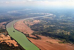
Ohio – rzeka w środkowo-wschodniej części Stanów Zjednoczonych. Długość 1579 km[2], powierzchnia dorzecza 525,6 tys. km². Jako jej początek uznawany jest zbieg rzek Allegheny i Monongahela w centrum miasta Pittsburgh w stanie Pensylwania[3].
Rzekę cechują duże wahania stanu wód, prowadzące do katastrofalnych powodzi. Połączona kanałami z Wielkimi Jeziorami[3].
Główne dopływy: Wabash, Kentucky, Cumberland, Tennessee, Green River, Kanawha, Big Sandy River i Licking River[2]. Większe miasta u wybrzeży: Pittsburgh, Louisville, Cincinnati[3].
Nazwa
Nazwa Ohio pochodzi od słowa ohiiyo’ z języka seneka (jeden z języków irokeskich), oznaczającego „dobrą rzekę”[4]. Inne podawane tłumaczenia to „wielka rzeka”[5] lub „piękna rzeka”[6].
W przeszłości rzeka nosiła również nazwę Mosopeleacipi od plemienia Mosopelea oraz Pellissippi (występująca również w rozmaitych wariantach, jak np. Polesipi, Pele Sipi, Pelisipi czy Peleson). Tę ostatnią nazwę w późniejszym okresie stosowano również dla rzeki Clinch[7].
Zobacz też
Przypisy
- ↑ Ohio River, Average discharge all over the years. Global River Discharge Database. [dostęp 2014-12-27]. (ang.).
- ↑ a b Ohio River, [w:] Encyclopædia Britannica [online] [dostęp 2022-10-03] (ang.).
- ↑ a b c paca zbiorowa: Encyklopedia Powszechna PWN. T. 3. M-R. Państwowe Wydawnictwo Naukowe, 1975, s. 353.
- ↑ American Indian Studies, web.archive.org, 2 lutego 2007 [dostęp 2021-03-10] [zarchiwizowane z adresu 2007-02-02].
- ↑ Ohio History Central, ohiohistorycentral.org [dostęp 2021-03-10].
- ↑ Henry Gannett, The origin of certain place names in the United States, Washington, Govt. Print. Off., 1905, s. 229 [dostęp 2021-01-14].
- ↑ The Winding River Home: Pellissippi State researches the meaning of ‘Pellissippi’, Pellissippi State News, 7 czerwca 2017 [dostęp 2021-03-10] [zarchiwizowane z adresu 2018-07-26] (ang.).
Media użyte na tej stronie
The flag of Navassa Island is simply the United States flag. It does not have a "local" flag or "unofficial" flag; it is an uninhabited island. The version with a profile view was based on Flags of the World and as a fictional design has no status warranting a place on any Wiki. It was made up by a random person with no connection to the island, it has never flown on the island, and it has never received any sort of recognition or validation by any authority. The person quoted on that page has no authority to bestow a flag, "unofficial" or otherwise, on the island.
Autor: Autor nie został podany w rozpoznawalny automatycznie sposób. Założono, że to Kmusser (w oparciu o szablon praw autorskich)., Licencja: CC BY-SA 2.5
This is a map of the Ohio River Watershed. I, Karl Musser, created it based on USGS data.
Astronaut photo of the confluence of the Mississippi and Ohio Rivers at Cairo, Illinois.
| Identification | |
|---|---|
| Mission | ISS012 (Expedition 12) |
| Roll | E |
| Frame | 15035 |
| Country or Geographic Name | USA-ILLINOIS |
| Features | CAIRO, MISSISSIPPI R., OHIO R. |
| Center Point Latitude | 37.0° N |
| Center Point Longitude | -89.2° E |
| Camera | |
| Camera Tilt | 17° |
| Camera Focal Length | 400 mm |
| Camera | Kodak DCS760C Electronic Still Camera |
| Film | 3060 x 2036 pixel CCD, RGBG array. |
| Quality | |
| Percentage of Cloud Cover | 0-10% |
| Nadir What is Nadir? | |
| Date | 2006-01-12 |
| Time | 18:38:03 |
| Nadir Point Latitude | 37.2° N |
| Nadir Point Longitude | -88.3° E |
| Nadir to Photo Center Direction | West |
| Sun Azimuth | 190° |
| Spacecraft Altitude | 185 nautical miles (343 km) |
| Sun Elevation Angle | 31° |
| Orbit Number | 867 |
| Original image caption | |
| The Ohio River becomes a tributary of the Mississippi River directly south of Cairo, Illinois, a small city on the spit of land where the rivers converge (at center of this astronaut photograph). Brown, sediment-laden water flowing generally northeast to south from the Ohio River is distinct from the green and relatively sediment-poor water of the Mississippi River (flowing northwest to south). The color of the rivers in this image is reversed from the usual condition of a green Ohio and a brown Mississippi. This suggests that the very high rainfall in December 2005 over the Appalachians and the northeastern United States has led to greater-than-normal amounts of sediment in the rivers and streams of the Ohio River watershed. The distinct boundary between the two river’s waters indicates that little to no mixing occurs even 5-6 kilometers (3-4 miles) downstream.
| |
Autor: Uwe Dedering, Licencja: CC BY-SA 3.0
Relief location map of the USA (without Hawaii and Alaska).
EquiDistantConicProjection : Central parallel :
* N: 37.0° N
Central meridian :
* E: 96.0° W
Standard parallels:
* 1: 32.0° N
* 2: 42.0° N
Made with Natural Earth. Free vector and raster map data @ naturalearthdata.com.
Formulas for x and y:
x = 50.0 + 124.03149777329222 * ((1.9694462586094064-({{{2}}}* pi / 180))
      * sin(0.6010514667026994 * ({{{3}}} + 96) * pi / 180))
y = 50.0 + 1.6155950752393982 * 124.03149777329222 * 0.02613325650382181
      - 1.6155950752393982  * 124.03149777329222 *
     (1.3236744353715044  - (1.9694462586094064-({{{2}}}* pi / 180))
      * cos(0.6010514667026994 * ({{{3}}} + 96) * pi / 180))


