Taebaek (góry)
 Położenie pasma Taebaek (na czerwono) na mapie Korei Południowej | |
| Kontynent | |
|---|---|
| Państwo | |
| Najwyższy szczyt | Seorak-san, szczyt Daechongbong |
Położenie na mapie Azji  | |
| 38°13′29″N 128°11′07″E/38,224722 128,185278 | |
Taebaek (Góry Wschodniokoreańskie; kor.: 태백산맥, Taebaek Sanmaek) – łańcuch górski we wschodniej części Półwyspu Koreańskiego, w Korei Południowej i Północnej. Rozciąga się wzdłuż wybrzeża Morza Japońskiego na długości ok. 500 km. Najwyższy szczyt, Seorak-san, osiąga 1708 m n.p.m. Na wschodzie góry stromo opadają do Morza Japońskiego, natomiast na zachodzie są łagodnie rozczłonkowane pasmami górskimi do nizin nad Morzem Żółtym. Występują złoża surowców mineralnych, m.in. rudy żelaza, węgla, wolframu, fluorytu i wapienia. Góry porośnięte są lasami[1].
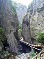
W paśmie znajdują się liczne pasma górskie oraz parki narodowe, np. Seoraksan, Odaesan, Sobaeksan i Juwangsan.
Znajdują się tu także ośrodki narciarskie, między innymi Yongpyong i Jeongseon, które były arenami Zimowych Igrzysk Olimpijskich 2018.
Galeria

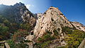
Szczyt Somunsubong

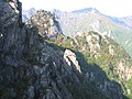
Misiryeong
Seoraksan

Widok ze szczytu Munsubong

Skała Ulsanbawi
Park Narodowy Seoraksan
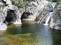
Wodospad Kuryong
Szczyt Gwongeumseong
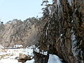
Park Narodowy Juwangsan
Park Narodowy Juwangsan
Masyw Kumgang
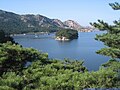
Jezioro Samil
Przypisy
- ↑ T’aebaek Mountains, [w:] Encyclopædia Britannica [online] [dostęp 2012-01-14] (ang.).
Media użyte na tej stronie
Autor: Uwe Dedering, Licencja: CC BY-SA 3.0
Relief Location map of Asia.
- Projection: Lambert azimuthal equal-area projection.
- Area of interest:
- N: 90.0° N
- S: -10.0° N
- W: 45.0° E
- E: 145.0° E
- Projection center:
- NS: 40.0° N
- WE: 95.0° E
- GMT projection: -JA95/50/20.0c
- GMT region: -R45.70461034279053/-25.193892806246794/-158.9850042825966/36.990936559512505r
- GMT region for grdcut: -R-20.0/-26.0/205.0/90.0r
- Relief: SRTM30plus.
- Made with Natural Earth. Free vector and raster map data @ naturalearthdata.com.


Black up-pointing triangle ▲, U+25B2 from Unicode-Block Geometric Shapes (25A0–25FF)

Autor: myself (User:Piotrus), Licencja: CC BY-SA 3.0
Seoraksan National Park area

Autor: Juliana Ng from Singapore, Licencja: CC BY 2.0
Seoraksan, Gangwon-do, South Korea

(c) Steve46814 z angielskiej Wikipedii, CC BY-SA 3.0
Mount Gwongeumseong in Seoraksan National Park
.jpg)
Autor: Uwe Brodrecht, Licencja: CC BY-SA 2.0
Nordkorea 2015 - Kumgang Gebirge - Kuryong Fasserfall
.jpg)
Autor: David Stanley from Nanaimo, Canada, Licencja: CC BY 2.0
Samil Lake near the Kumgang Mountains in the southeast corner of the Democratic People's Republic of Korea.

Autor: Straitgate, Licencja: CC BY-SA 4.0
Somunsubong Peak on Mt. Taebaek, South Korea (July 2015)
Autor:
- South_Korea_location_map.svg: NordNordWest
- South_Korea_Topography.png'
- derivative work: 배우는사람
Topography map version designed to be used as an alternative map to File:South Korea location map.svg with the Taebaek Mountains region marked in red

Autor: Misiryeong, Licencja: CC BY-SA 4.0
Ulsanbawi Rock as seen from the Misiryeong Ridge

Autor: Dcpeets, Licencja: CC BY-SA 3.0
Main peaks of Taebaeksan viewed from Munsubong, one of the mountain's other peaks

Autor: Misiryeong, Licencja: CC BY-SA 4.0
At the Top of Misiryeong Ridge, Taebaek Mountains, Gangwon Province, Korea - There are two ways to get from Inje to Sokcho: one is through the 'Misiryeong Tunnel' and the other is to go over 'Misiryeong Yetgil'. If you have more time to appreciate nature, you should take the mountain route because magnificent scenery awaits visitors at the top.

.jpg)

Autor: garycycles3, Licencja: CC BY 2.0
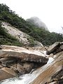
Canyon in Juwangsan national park