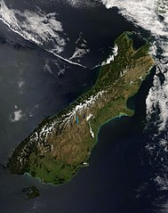
Wyspa Południowa (Nowa Zelandia)
| Ten artykuł od 2012-11 wymaga zweryfikowania podanych informacji. |
| ||
 | ||
| Państwo | ||
| Akwen | Ocean Spokojny | |
| Archipelag | Nowa Zelandia | |
| Powierzchnia | 150 416[1] km² | |
| Populacja (2010 VI) • liczba ludności • gęstość | 1 038 300 6,9 os./km² | |
 | ||
Wyspa Południowa (maori: Te Wai Pounamu lub Tavai Poenammoo tj. "Wody Szmaragdów", czasem też Te Waka a Māui, "Łódź Māui") – największa z wysp Nowej Zelandii, o powierzchni 150 523 km². Położona jest pomiędzy Morzem Tasmana a Oceanem Spokojnym. Od Wyspy Północnej oddzielona jest cieśniną Cooka.
Jest wyspą górzystą - głównym pasmem są Alpy Południowe ze szczytami Góra Cooka 3764 m n.p.m. oraz Góra Tasmana 3497 m n.p.m. Tereny nizinne występują jedynie na obrzeżach wyspy, zwłaszcza w jej części wschodniej i południowej.
Długość linii brzegowej wynosi 3704 km. Szczególnie rozbudowana linia brzegowa występuje w części południowo-zachodniej, gdzie wysokie góry schodzą wprost do morza (liczne fiordy) oraz na krańcu północnym wyspy.
Na wyspie, zwłaszcza w jej części centralnej i południowo-zachodniej, występuje wiele jezior, wypełniających głównie wąskie, kręte doliny polodowcowe. Największym powierzchniowo jeziorem na wyspie jest położone w jej części południowo-zachodniej jezioro Te Anau (344 km²). Drugim co do wielkości na wyspie jest jezioro Wakatipu (291 km²). Pomiędzy miejscowościami Arrowtown i Queenstown znajduje się niewielkie, lustrzane jezioro Hayes.
Na wyspie występują jaskinie nabrzeżne Cathedral Caves.
Miasta Wyspy Południowej
Największym miastem jest Christchurch, liczące 390,3 tys. mieszkańców. Ważniejsze miasta i osiedla na Wyspie Południowej to, m.in.:
- Ashburton 17,8 tys. mieszkańców
- Blenheim 30,2 tys.
- Christchurch 390,3 tys.
- Dunedin 116,6 tys.
- Greymouth 10,0 tys.
- Hokitika 3,1 tys.
- Invercargill 48,7 tys.
- Kaikoura 2,2 tys.
- Nelson 59,8 tys.
- Oamaru 13,0 tys.
- Te Anau 1,9 tys.
- Timaru 27,6 tys.
- Queenstown 10,4 tys.
- Wanaka 5,0 tys.
- Westport 3,9 tys.
Przypisy
- ↑ New Zealand Official Yearbook 2010, Table 1.01 Land area of New Zealand
Media użyte na tej stronie
Flag of New Zealand. Specification: http://www.mch.govt.nz/nzflag/description.html , quoting New Zealand Gazette, 27 June 1902.
This image provides a nearly cloud-free view of the South Island of New Zealand, from the Moderate Resolution Imaging Spectroradiometer (MODIS) on NASA’s Aqua satellite.
From Earth Observatory website:
Colors ranging from deep brown to stark white give New Zealand’s South Island its intense beauty. The snow-capped Southern Alps run down the northern shore of the island. The highest peak in the range (and in New Zealand) is Aoraki/Mount Cook at 3,754 meters (12,316 ft). The mountains are rising as the Pacific Plate, the section of the Earth’s crust that holds the Pacific Ocean, including parts of New Zealand’s South Island, sinks beneath the Australia Plate, which holds the rest of New Zealand. The collision between the two plates pushes the mountains up and fosters volcanoes on the country’s North Island. Not only do the mountains mark the line between two tectonic plates, they also create different climate regions, which are visible in the image.
The shoreline west of the mountains receives more rain than any other place in the South Island. The rain-drenched shoreline is deep green, covered by temperature rain forests. To the south, the shore turns dark brown where rocky mountain terrain extends to the Pacific Ocean. Fingers of water cut into the western shore where glaciers cut deep fjords over time.
The landscape on the east side of the mountains is dramatically different. Hidden in the rain shadow of the Southern Alps, the region receives less rain than its neighbor and is correspondingly tan instead of green. The dry landscape is punctuated by alpine glacier lakes that hang like sapphire and aquamarine pendants from the mountain chain. Rivers also drain melting snow from the south side of the mountains into the Pacific Ocean. Over eons, the rivers have deposited finely ground rock from the mountains onto the landscape below, building nutrient-rich alluvial plains. Sediment washing into the ocean colors the water green blue. Spots of bright green accentuate the plains, an indication that these regions are cultivated. The large image reveals the grid of green made by fields of crops across the plains.
The Moderate Resolution Imaging Spectroradiometer (MODIS) on NASA’s Aqua satellite captured this photo-like image of the South Island on December 7, 2007, as spring began to give way to summer in this southern location. Places where the sensor detected fire are marked with red circles. The large image has a resolution of 250 meters per pixel, the highest resolution image available. The MODIS Rapid Response System provides the image in additional resolutions.
NASA image courtesy Jeff Schmaltz, MODIS Rapid Response Team at NASA GSFCAutor:
- New_Zealand_location_map.svg: NordNordWest
- derivative work: Виктор В (talk)
Location map of New Zealand


