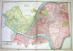
Allegheny (Pittsburgh)
 Położenie Allegheny (kolor żółty) względem Pittsburgha (kolor czerwony) w roku 1898 | |
| Państwo | |
|---|---|
| Stan | |
| Populacja • liczba ludności |
|
| Portal | |
Allegheny – w latach 1788–1907 miasto, obecnie część Pittsburgha w Pensylwanii w Stanach Zjednoczonych.
Obszar historycznego Allegheny położony jest na północ od zbiegu rzek Allegheny i Ohio, naprzeciw centrum Pittsburgha, zostało do niego włączona w 1907 roku. Obszar dawnego miasta Allegheny obejmuje teraz następujące dzielnice: Allegheny Center, Allegheny West, Brighton Heights, California-Kirkbride, Central Northside, Chateau, East Allegheny, Fineview, Manchester, Marshall-Shadeland, North Shore, Northview Heights, Perry North, Perry South, Spring Garden, Spring Hill–City View, Summer Hill oraz Troy Hill.
W latach 1884–1909 mieścił się tu Dom Biblijny Towarzystwa Strażnica[1].
Przypisy
- ↑ Betel w Brooklynie — 100 lat historii. „Strażnica Zwiastująca Królestwo Jehowy”. CXXX, s. 22-25, 1 maja 2009. Towarzystwo Strażnica. ISSN 1234-1150.
Linki zewnętrzne
Media użyte na tej stronie
Autor: Uwe Dedering, Licencja: CC BY-SA 3.0
Location map of the USA (without Hawaii and Alaska).
EquiDistantConicProjection:
Central parallel:
* N: 37.0° N
Central meridian:
* E: 96.0° W
Standard parallels:
* 1: 32.0° N
* 2: 42.0° N
Made with Natural Earth. Free vector and raster map data @ naturalearthdata.com.
Formulas for x and y:
x = 50.0 + 124.03149777329222 * ((1.9694462586094064-({{{2}}}* pi / 180))
      * sin(0.6010514667026994 * ({{{3}}} + 96) * pi / 180))
y = 50.0 + 1.6155950752393982 * 124.03149777329222 * 0.02613325650382181
      - 1.6155950752393982  * 124.03149777329222 *
     (1.3236744353715044  - (1.9694462586094064-({{{2}}}* pi / 180))
      * cos(0.6010514667026994 * ({{{3}}} + 96) * pi / 180))
The flag of Navassa Island is simply the United States flag. It does not have a "local" flag or "unofficial" flag; it is an uninhabited island. The version with a profile view was based on Flags of the World and as a fictional design has no status warranting a place on any Wiki. It was made up by a random person with no connection to the island, it has never flown on the island, and it has never received any sort of recognition or validation by any authority. The person quoted on that page has no authority to bestow a flag, "unofficial" or otherwise, on the island.
Autor: Alexrk2, Licencja: CC BY 3.0
Location map of Pennsylvania, USA


