Amiens
.JPG) | |||
| |||
| Państwo | |||
|---|---|---|---|
| Region | |||
| Departament | |||
| Mer | |||
| Powierzchnia | 49,46[1] km² | ||
| Wysokość | 33 m n.p.m. | ||
| Populacja (2018) • liczba ludności • gęstość |
| ||
| Nr kierunkowy | 0033 | ||
| Kod pocztowy | 80 000 | ||
Położenie na mapie Sommy  (c) Eric Gaba, Wikimedia Commons user Sting, CC BY-SA 3.0 | |||
Położenie na mapie Francji  | |||
Położenie na mapie regionu Hauts-de-France  | |||
| Strona internetowa | |||
| Portal | |||
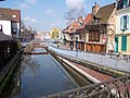
Amiens – miasto w północnej Francji, w regionie Hauts-de-France, ośrodek administracyjny departamentu Somma, położone nad rzeką Sommą. Według danych na rok 2018 miasto zamieszkiwało 136 545 osób[3], a gęstość wyniosła 2760,7 osób/km².
Historia
Osada założona w XII wieku, średniowieczne centrum produkcji sukna. W 1802 roku miejsce zawarcia krótkotrwałego pokoju między napoleońską Francją a Anglią. Podczas I wojny światowej trwały tam ciężkie walki Ententy z Niemcami.
Obecnie w mieście zlokalizowany jest przemysł, m.in. zakłady oponiarskie Dunlopa i przemysł włókienniczy.
Zabytki
- Katedra w Amiens z XIII wieku wpisana jest na listę światowego dziedzictwa UNESCO.
- gotyckie kościoły St. Germain i St. Leu.
Miasta partnerskie
Osoby związane z Amiens
- Juliusz Verne – radny miejski w latach 1888-1903[4][5][6], pisarz, protoplasta literatury fantastycznonaukowej
- Maurice Boitel – malarz
- Emmanuel Macron – polityk, od 2017 prezydent Francji
Galeria

Plac Gambetta w latach 80

Nawa katedry miejskiej
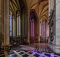
Wnętrze katedry miejskiej

Zobacz też
Przypisy
- ↑ Statystyki na stronie francuskiego urzędu statystycznego (fr.)
- ↑ Populacja na stronie francuskiego urzędu statystycznego (fr.)
- ↑ Populations légales 2018 − Ces données sont disponibles sur toutes les communes de France hors Mayotte | Insee, www.insee.fr [dostęp 2021-03-29].
- ↑ Herbert R. Lottman Juliusz Verne, strona 307, Państwowy Instytut Wydawniczy, Warszawa 1999, ISBN 83-06-02751-5
- ↑ https://web.archive.org/web/20100329104431/http://jv.gilead.org.il/butcher/chron.html Kalendarium Juliusza Verne’a według Williama Butchera
- ↑ Jules Verne Backwards to Britain, strona 226, Chambers, Edinburgh New York, 1992, ISBN 0-550-23000-9
Linki zewnętrzne
Media użyte na tej stronie
Somme department location map.svg
(c) Eric Gaba, Wikimedia Commons user Sting, CC BY-SA 3.0
Blank administrative map of the department of Somme, France, as in December 2014, for geo-location purpose, with distinct boundaries for regions, departments and arrondissements.
(c) Eric Gaba, Wikimedia Commons user Sting, CC BY-SA 3.0
Blank administrative map of the department of Somme, France, as in December 2014, for geo-location purpose, with distinct boundaries for regions, departments and arrondissements.
France location map-Regions and departements-2016.svg
Autor: Superbenjamin, Licencja: CC BY-SA 4.0
Blank administrative map of France for geo-location purpose, with regions and departements distinguished. Approximate scale : 1:3,000,000
Autor: Superbenjamin, Licencja: CC BY-SA 4.0
Blank administrative map of France for geo-location purpose, with regions and departements distinguished. Approximate scale : 1:3,000,000
Hauts-de-France region location map.svg
Autor: Flappiefh, Licencja: CC BY-SA 4.0
Carte administrative vierge de la région Hauts-de-France, France, destinée à la géolocalisation.
Autor: Flappiefh, Licencja: CC BY-SA 4.0
Carte administrative vierge de la région Hauts-de-France, France, destinée à la géolocalisation.
.svg)


Flag of the United States.svg
The flag of Navassa Island is simply the United States flag. It does not have a "local" flag or "unofficial" flag; it is an uninhabited island. The version with a profile view was based on Flags of the World and as a fictional design has no status warranting a place on any Wiki. It was made up by a random person with no connection to the island, it has never flown on the island, and it has never received any sort of recognition or validation by any authority. The person quoted on that page has no authority to bestow a flag, "unofficial" or otherwise, on the island.
The flag of Navassa Island is simply the United States flag. It does not have a "local" flag or "unofficial" flag; it is an uninhabited island. The version with a profile view was based on Flags of the World and as a fictional design has no status warranting a place on any Wiki. It was made up by a random person with no connection to the island, it has never flown on the island, and it has never received any sort of recognition or validation by any authority. The person quoted on that page has no authority to bestow a flag, "unofficial" or otherwise, on the island.

Amiens Cathedral Ambulatory, Picardy, France - Diliff.jpg
Autor: Diliff, Licencja: CC BY-SA 3.0
The ambulatory of Amiens Cathedral in Picardy, France.
Autor: Diliff, Licencja: CC BY-SA 3.0
The ambulatory of Amiens Cathedral in Picardy, France.

0 Amiens - Cathédrale Notre-Dame (1).JPG
Autor: Jean-Pol GRANDMONT, Licencja: CC BY 3.0
Amiens (Somme - France), facade of the Cathedral of Our Lady of Amiens (1220-1269).
Autor: Jean-Pol GRANDMONT, Licencja: CC BY 3.0
Amiens (Somme - France), facade of the Cathedral of Our Lady of Amiens (1220-1269).

Jules Victor Génisson - Interior da Catedral de Amiens - 1842.jpg
Interior of the Cathedral of Amiens, 1842, oil on canvas, by Jules Victor Génisson. Displayed in the Pinacoteca do Estado de São Paulo.
Interior of the Cathedral of Amiens, 1842, oil on canvas, by Jules Victor Génisson. Displayed in the Pinacoteca do Estado de São Paulo.

Armoirie ville fr Amiens.svg
Autor: A.T-2014, Licencja: CC BY-SA 3.0
Armoiries de la ville française d'Amiens, Somme (80)
Autor: A.T-2014, Licencja: CC BY-SA 3.0
Armoiries de la ville française d'Amiens, Somme (80)