Andamany i Nikobary
| Ten artykuł od 2015-02 wymaga zweryfikowania podanych informacji. |
| ||||
| ||||
 | ||||
| Państwo | ||||
| Siedziba | Port Blair | |||
| Kod ISO 3166-2 | IN-AN | |||
| Powierzchnia | 8249 km² | |||
| Populacja (2012) • liczba ludności | 380 500 | |||
| • gęstość | 46 os./km² | |||
Położenie na mapie Indii | ||||
| Strona internetowa | ||||
Andamany i Nikobary (hindi अंडमान और निकोबार द्वीप, trb.: Andaman aur Nikobar Dwip, trl.: Aṁdamān aur Nikobār Dvīp; ang. Andaman and Nicobar Islands) – jedno z terytoriów związkowych Indii, położone na wyspach leżących we wschodniej części Zatoki Bengalskiej na pograniczu z Morzem Andamańskim. Stolicą terytorium, a zarazem największym miastem jest Port Blair. Terytorium zostało utworzone 1 listopada 1956 roku. Jego powierzchnia to 8249 km², a zamieszkane jest przez około 0,4 mln osób. W skład terytorium wchodzą dwa archipelagi: Andamany i Nikobary.
Archipelag Andamany
Archipelag Andamany składa się z pięciu głównych wysp oraz z ponad 200 mniejszych wysepek.
Największymi wyspami archipelagu są Andaman Północny, Andaman Południowy, Andaman Środkowy i Mały Andaman.
Inne wyspy tworzące archipelag Andamany to:
- Barren
- Cinque Island
- Great Coco Island
- Havelock Island
- Henry Lawrence Island
- Interview Island
- Landfall Island
- N. Sentinel Island
- Narcondan
- Rutland Island
- Smith Island
- Wilson Island
Archipelag Nikobary
Archipelag Nikobary składa się z 19 wysp. W tej grupie jest 7 wysp niezamieszkanych.
Archipelag tworzą wyspy:
- Batti Malv
- Camorta Island
- Kar Nikobar
- Chaura Island
- Katchall Island
- Nancowry Island
- Mały Nikobar
- Wielki Nikobar
- Tarasa Dwip Island
- Tillanchang Dwip
- Trinkat Island
Media użyte na tej stronie
The Flag of India. The colours are saffron, white and green. The navy blue wheel in the center of the flag has a diameter approximately the width of the white band and is called Ashoka's Dharma Chakra, with 24 spokes (after Ashoka, the Great). Each spoke depicts one hour of the day, portraying the prevalence of righteousness all 24 hours of it.
Autor: Biswarup Ganguly, Licencja: CC BY 3.0
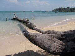
Wandoor is a small village and beach near the southern tip of South Andaman, it is about 30 Kms from Port Blair by road. There is a National Marine Park.
Vectorized version of Seal of Government of Andaman and Nicobar used by the state government for public notices in the press and for publicity purposes. The emblem of India is the image used on the India wikipedia article.


