Arleta (Los Angeles)
| ||||
| ||||
| Państwo | ||||
| Stan | ||||
| Hrabstwo | Los Angeles | |||
| Powierzchnia | 8 km² | |||
| Populacja (2008) • liczba ludności • gęstość | 32 622 4100 os./km² | |||
| Kod pocztowy | 91331 | |||
| Strefa czasowa | UTC-08:00 UTC-07:00 | |||
 | ||||
Położenie na mapie Kalifornii  | ||||
Położenie na mapie Stanów Zjednoczonych  | ||||
| Portal | ||||
Arleta – obszar niemunicypalny w Hrabstwie Los Angeles w północno-wschodniej części San Fernando Valley.
Dzielnica była uważana za "umiarkowanie zróżnicowaną" etnicznie w Los Angeles, ze stosunkowo wysokim procentem Latynosów. Szczegółowe rozbicie: Latynosi – 71,7%; Azjaci – 11,0%; biali – 13,2%; czarni – 2,2% pozostali – 1,9%. Meksyk (55,3%) oraz Salwador (11,2%) były najczęstszymi miejscami narodzin 46% mieszkańców, którzy urodzili się poza granicami USA, nawet dla Los Angeles jest to wysoki procent[1].
Geografia i transport
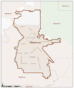
Arleta graniczy z dzielnicami Los Angeles Mission Hills i North Hills na północy, Sun Valley na wschodzie, Pacoima na północnym zachodzie i Panorama City na zachodzie. Dzielnica leży na obszarze 29. dystryktu federalnego California's 29th congressional district i 6. dystryktu Los Angeles City Council.
Do Arlety można dojechać autostradą międzystanową I-5 i autostradą Hollywood Freeway (SR 170). Głównymi arteriami są Van Nuys Boulevard, Woodman Avenue, Arleta Avenue oraz ulice Sheldon, Branford, Osborne i Terra Bella. Przez dzielnicę przebiega linia 744 systemu szybkiego transportu autobusowego Metro Rapid, linia 158 systemu transportu autobusowego Metro Local.
Granice Arlety tworzą Paxton Avenue na północnym zachodzie, Laurel Canyon Boulevard na północnym wschodzie, Tonopah Avenue na południowym wschodzie i Woodman Avenue na południowym zachodzie.
Rekreacja
W Arleta znajduje się Branford Park. Obiekt posiada widownię, oświetlone boiska do baseballa, oświetlone odkryte boiska do koszykówki, plac zabaw dla dzieci, kryte sale gimnastyczne, kuchnię, salę muzyczną, stoły piknikowe, oświetlone boisko do piłki nożnej, oświetlone korty tenisowe, boiska do siatkówki i wiele innych obiektów sportowych, rekreacyjnych i użytkowych[2]. Kolejnym parkiem jest Devonshire Arleta Park[3].
Galeria
Mapa 29 dystryktu

Mapa Arlety na podstawie map Google
Zobacz też
Przypisy
- ↑ Mapping L.A. – Arleta (ang.). Los Angeles Times. [dostęp 2016-02-15].
- ↑ City of Los Angeles "Branford Park" (ang.). [dostęp 2016-02-15].
- ↑ City of Los Angeles "Devonshire Arleta Park". [dostęp 2016-02-15].
Linki zewnętrzne
| Tematy |
|
|---|---|
| Władze |
|
| Rejony |
|

- Portal:Wielkie Los Angeles
- Wikiprojekt:Kalifornia
| Dzielnice i osiedla |
|
|---|---|
| Ciekawe miejsca |
|
| Zobacz też |

- Downtown
- Northeast/Eastside
- Harbor Area
- Greater Hollywood
- Westlake/Silver Lake/Los Feliz
- San Fernando Valley
- South Los Angeles
- Westside
- Wilshire
- Portal:Wielkie Los Angeles
- Wikiprojekt:Kalifornia
Media użyte na tej stronie
Autor: NordNordWest, Licencja: CC BY 3.0
Location map of California, USA
Autor: Uwe Dedering, Licencja: CC BY-SA 3.0
Location map of the USA (without Hawaii and Alaska).
EquiDistantConicProjection:
Central parallel:
* N: 37.0° N
Central meridian:
* E: 96.0° W
Standard parallels:
* 1: 32.0° N
* 2: 42.0° N
Made with Natural Earth. Free vector and raster map data @ naturalearthdata.com.
Formulas for x and y:
x = 50.0 + 124.03149777329222 * ((1.9694462586094064-({{{2}}}* pi / 180))
      * sin(0.6010514667026994 * ({{{3}}} + 96) * pi / 180))
y = 50.0 + 1.6155950752393982 * 124.03149777329222 * 0.02613325650382181
      - 1.6155950752393982  * 124.03149777329222 *
     (1.3236744353715044  - (1.9694462586094064-({{{2}}}* pi / 180))
      * cos(0.6010514667026994 * ({{{3}}} + 96) * pi / 180))

The flag of Navassa Island is simply the United States flag. It does not have a "local" flag or "unofficial" flag; it is an uninhabited island. The version with a profile view was based on Flags of the World and as a fictional design has no status warranting a place on any Wiki. It was made up by a random person with no connection to the island, it has never flown on the island, and it has never received any sort of recognition or validation by any authority. The person quoted on that page has no authority to bestow a flag, "unofficial" or otherwise, on the island.

Flag of California. This version is designed to accurately depict the standard print of the bear as well as adhere to the official flag code regarding the size, position and proportion of the bear, the colors of the flag, and the position and size of the star.

Autor: OpenStreetMap contributors, Licencja: ODbL
Map of Arleta neighborhood, Los Angeles, California based on Google maps

Map of the California's 29th congressional district in the U.S. House of Representatives (as of 1 Jan 2013).
- Located in the north central San Fernando Valley, Los Angeles County, California.
Autor: Los Angeles Times, Licencja: CC BY 2.0
Map of Arleta, California, as drawn by the Los Angeles Times.
- Other information
Boundary map as drawn by the Los Angeles Times on a CC-by-SA background. Note at bottom right of map on the L.A. Times website noted above says "CC-by-SA" (which gives permission to use the map). There is a link there to https://creativecommons.org/licenses/by-sa/2.0, which explains the meaning thereof. The base map is credited to http://www.openstreetmap.org/The Times spells all this out at http://projects.latimes.com/mapping-la/about/#the-data
