Autostrada A26 (Francja)
| Długość | 350 km | ||||||||||||||||||||||||||||||||||||||||||||||||||||||||||||||||||||||||||||||||||||||||||||||||||||||||||||||||||||||||||||||||||||||||||
| Departamenty | Pas-de-Calais, Nord, Aisne, Marna, Aube | ||||||||||||||||||||||||||||||||||||||||||||||||||||||||||||||||||||||||||||||||||||||||||||||||||||||||||||||||||||||||||||||||||||||||||
| Mapa | |||||||||||||||||||||||||||||||||||||||||||||||||||||||||||||||||||||||||||||||||||||||||||||||||||||||||||||||||||||||||||||||||||||||||||
 | |||||||||||||||||||||||||||||||||||||||||||||||||||||||||||||||||||||||||||||||||||||||||||||||||||||||||||||||||||||||||||||||||||||||||||
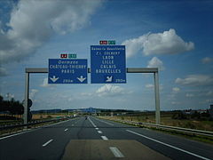
| Zdjęcie | |||||||||||||||||||||||||||||||||||||||||||||||||||||||||||||||||||||||||||||||||||||||||||||||||||||||||||||||||||||||||||||||||||||||||||
(c) I, Titoine08, CC-BY-SA-3.0 | |||||||||||||||||||||||||||||||||||||||||||||||||||||||||||||||||||||||||||||||||||||||||||||||||||||||||||||||||||||||||||||||||||||||||||
| |||||||||||||||||||||||||||||||||||||||||||||||||||||||||||||||||||||||||||||||||||||||||||||||||||||||||||||||||||||||||||||||||||||||||||
Autostrada A26 (fr. Autoroute A26) także Autoroute des Anglais (pl. Autostrada Anglików) – autostrada w północnej Francji w ciągu tras europejskich E15 oraz E17.
Informacje ogólne
Na całej długości autostrady istnieją dwa pasy ruchu w każdą stronę. Długość autostrady wynosi ok. 350 km (390 km wraz z odcinkiem wspólnym z autostradą A 4).
Przebieg trasy
A26 rozpoczyna się w Calais.
Linki zewnętrzne
| ||||||||||||||||||||||
Media użyte na tej stronie
Sign no. 392 - Customs, darker version
prom rzeka-icon.
(Motorway) tunnel Icon. Drawing similar to Swiss road signs.
Gas station symbol
AIGA Air Transportation sign (inverted)
Autor: https://phabricator.wikimedia.org/diffusion/GOJU/browse/master/AUTHORS.txt, Licencja: MIT
An icon from the OOjs UI MediaWiki lib.
Parking icon. Drawing similar to Polish road signs.
Autor: David Vignoni / ICON KING, Licencja: LGPL
Icon from Nuvola icon theme for KDE 3.x / GNOME 2.
Autor: https://phabricator.wikimedia.org/diffusion/GOJU/browse/master/AUTHORS.txt, Licencja: MIT
An icon from the OOjs UI MediaWiki lib.
French motorway A16
Autor: David Vignoni / ICON KING, Licencja: LGPL
Icon from Nuvola icon theme for KDE 3.x / GNOME 2.
French motorway shield
French motorway A26
Map showing France with the French flag.
French motorway A1
French motorway A29
French motorway A2
French motorway A21
French motorway A5
French motorway A4


