Autostrada międzystanowa nr 64
| Długość | 937,71 mili / 1500,34[1] km |
| Stany | Missouri, Illinois, Indiana, Kentucky, Wirginia Zachodnia, Wirginia |
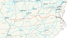
| Mapa | |
 | |
| Zdjęcie | |
 Most w ciągu I-64 łączący Missouri z Illinois | |
Interstate 64 − autostrada międzystanowa w USA. Prowadzi z Wentzville do Norfolk (stanowi jego wschodnią i południową obwodnicę). Przebiega przez stany: Missouri, Illinois, Indiana, Kentucky, Wirginia Zachodnia i Wirginia. Jej długość to 937,71 mili (1500,34 km)[1].
Przebieg
 Missouri
 Illinois
- East St. Louis
- Mount Vernon

 Indiana
 Kentucky
 Wirginia Zachodnia
- Huntington
- Charleston

- Beckley

- White
- Sulphur Springs
 Wirginia
- Covington
- Clifton Forge
- Lexington

- Staunton

- Waynesboro
- Charlottesville
- Richmond


- Williamsburg
- Newport News
- Hampton

- Norfolk


Przypisy
- ↑ a b Interstate-Guide: Interstate 64 (ang.)
| ||||||||||||||
Media użyte na tej stronie
Sign no. 392 - Customs, darker version
prom rzeka-icon.
(Motorway) tunnel Icon. Drawing similar to Swiss road signs.
Gas station symbol
AIGA Air Transportation sign (inverted)
Uses the Roadgeek 2005 fonts. (United States law does not permit the copyrighting of typeface designs, and the fonts are meant to be copies of a U.S. Government-produced work anyway.) Colors are from [1] (Pantone Red 187 and Blue 294), converted to RGB by [2]. The outside border has a width of 1 (1 mm) and a color of black so it shows up; in reality, signs have no outside border.
Uses the Roadgeek 2005 fonts. (United States law does not permit the copyrighting of typeface designs, and the fonts are meant to be copies of a U.S. Government-produced work anyway.) Colors are from [1] (Pantone Red 187 and Blue 294), converted to RGB by [2]. The outside border has a width of 1 (1 mm) and a color of black so it shows up; in reality, signs have no outside border.
Autor: Autor nie został podany w rozpoznawalny automatycznie sposób. Założono, że to Kelly Martin (w oparciu o szablon praw autorskich)., Licencja: CC-BY-SA-3.0
The Poplar Street Bridge, a major highway bridge over the Mississippi River near St. Louis, Missouri. Photographed June 15, 2006 from the Jefferson National Expansion Memorial, St. Louis, Missouri by Kelly Martin.
600 mm by 600 mm (24 in by 24 in) Interstate shield, made to the specifications of the 2004 edition of Standard Highway Signs (sign M1-1). Uses the Roadgeek 2005 fonts. (United States law does not permit the copyrighting of typeface designs, and the fonts are meant to be copies of a U.S. Government-produced work anyway.) Colors are from [1] (Pantone Red 187 and Blue 294), converted to RGB by [2]. The outside border has a width of 1 (1 mm) and a color of black so it shows up; in reality, signs have no outside border.


