Barentsburg
 Panorama miejscowości i otoczenia | |||
| |||
| Państwo | |||
|---|---|---|---|
| Terytorium zależne | |||
| Populacja • liczba ludności |
| ||
| Kod pocztowy | 9178 | ||
| Tablice rejestracyjne | ZN | ||
Położenie na mapie Svalbardu  | |||
Położenie na mapie Arktyki  | |||
| Portal | |||
Barentsburg (ros. Баренцбург) jest drugim pod względem wielkości osiedlem na Svalbardzie, zamieszkuje go ok. 470 osób, głównie Rosjanie i Ukraińcy. Większość mieszkańców pracowała w kopalni węgla rosyjskiej firmy Trust Arktikugol (Арктикуголь), obecnie zamykanej. Odległość do Longyearbyen, największego osiedla na Svalbardzie to ok. 55 km, jednak nigdy nie wybudowano drogi łączącej te miejscowości, chociaż w ostatnich latach zaczęto planować budowę takowej.
Galeria

Prawosławna cerkiew

Szkoła

Biust Lenina
 (c) Andrew Shiva / Wikipedia, CC BY-SA 4.0
Port
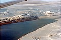
Barentsburg z lotu ptaka

Konsulat Rosji
Media użyte na tej stronie

Norway Svalbard location map.svg
Autor: NordNordWest, Licencja: CC BY-SA 3.0
Location map of Svalbard, Norway
Autor: NordNordWest, Licencja: CC BY-SA 3.0
Location map of Svalbard, Norway
.jpg)
Barentsburg Harbor (Spitsbergen).jpg
(c) Andrew Shiva / Wikipedia, CC BY-SA 4.0
The Svalbard archipelago is the northernmost part of Norway. Of the islands, Spitsbergen is the largest and is host to Svalbard’s Administrative center, the settlement of Longyearbyen (population in 2008 was 2,040). Barentsburg, the second largest settlement on the island, has been home to Russian-owned Arktikugol (Russian: Арктикуголь), a coal mining company, since the late 1920’s.

Barentsburg crest.jpg
Barentsburg Crest photo by user
Barentsburg Crest photo by user


Consulate of Russia in Barentsburg.jpg
Autor: Sigurd R, Licencja: CC BY-SA 3.0
Consulate of Russia in Barentsburg
Autor: Sigurd R, Licencja: CC BY-SA 3.0
Consulate of Russia in Barentsburg
.jpg)
Barentsburg1 (js).jpg
Autor: Jerzy Strzelecki, Licencja: CC BY-SA 3.0
Svalbard, Barentsburg, Gronfjorden
Autor: Jerzy Strzelecki, Licencja: CC BY-SA 3.0
Svalbard, Barentsburg, Gronfjorden

Barentsburg Lenin.jpg
Autor: Smtunli, Svein-Magne Tunli - http://www.tunliweb.no/SM/English/sm_eng.htm, Licencja: CC BY-SA 3.0
Lenin statue in Barentsburg, Svalbard. Lenin statue. It may be only the world's second most northernmost statue of Lenin (the top spot still belongs to Pyramiden at Svalbard). There's a five-pointed star and the Communist-era slogan Miru Mir, or "Peace to the World". The sign also serves a useful function during winter, as when the star becomes visible again, the polar night has ended and summer is coming.

Barentsburg IMG 2473 Barentsburg skole.jpg
Autor: Bjoertvedt, Licencja: CC BY-SA 3.0
Barentsburg elementary school, Spitsbergen
Autor: Bjoertvedt, Licencja: CC BY-SA 3.0
Barentsburg elementary school, Spitsbergen
Arctic Ocean location map 2.svg
Autor: source file by Tentotwo, Licencja: CC BY-SA 3.0
Autor: source file by Tentotwo, Licencja: CC BY-SA 3.0
Location Map of the Arctic Ocean
- Projection: Azimuthal equidistant projection.
- Area of interest:
- N: 90.0° N
- S: 70.0° N
- W: -180.0° E
- E: 180.0° E
- Projection center:
- NS: 90° N
- WE: 0° E