Bellenden Ker Range
| ||
 Mount Bartle Frere | ||
| Kontynent | Australia | |
| Państwo | ||
| Najwyższy szczyt | Mount Bartle Frere (1622 m) | |
| Jednostka dominująca | Wielkie Góry Wododziałowe | |
Położenie na mapie Australii  | ||
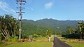
Bellenden Ker Range (Wooroonooran Range) – pasmo górskie w Wielkich Górach Wododziałowych w Australii, w północno-wschodniej części stanu Queensland. Ciągnie się wzdłuż wybrzeża Oceanu Spokojnego na południe od Cairns[1][2].
Znajdują się tu najwyższe szczyty stanu Queensland. Są to: Mount Bartle Frere (1622 m) i Mount Bartle Frere (1593 m).
W 1988 roku pasmo zostało wpisane na listę światowego dziedzictwa UNESCO, a w 1992 roku powstał Wooroonooran National Park, obejmujący część pasma z jej najwyższymi szczytami. Ma on powierzchnię 798 km²[1]. Główną atrakcją turystyczną parku jest Walsh's Pyramid (922 m) uważana za najwyższą naturalną piramidą na świecie[3].
Pasmo pokrywają lasy deszczowe. Znajdują się tu liczne wodospady, m.in. Josephine Falls, Tchupala Falls i Silver Creek Falls[1].
Pierwszym Europejczykiem, który dotarł do Bellenden Ker Range był poszukiwacz złota i odkrywca Christie Palmerston w 1882 roku. Cztery lata później jako pierwszy wspiął się on na Mount Bartle Frere[4].

Walsh’s Pyramid
Mount Bartle Frere
Przypisy
- ↑ a b c Wielka Encyklopedia Gór i Alpinizmu, tom 5, Góry Afryki, Antarktydy, Australii i Oceanii, Wydawnictwo STAPIS, Katowice, 2010, ISBN 978-83-61050-39-1.
- ↑ The Great Geographical Atlas, Rand McNally & Company, 1989, ISBN 0-528-83384-7.
- ↑ Walshs Pyramid, Wooroonooran National Park, www.npsr.qld.gov.au [dostęp 2018-06-17] (ang.).
- ↑ Wooroonooran National Park, Cairns & The Tropics - Explore Australia, web.archive.org, 6 lipca 2019 [dostęp 2021-04-05] [zarchiwizowane z adresu 2019-07-06].
Media użyte na tej stronie
Autor: , Licencja: CC BY-SA 3.0
Relief map of Australia, including the borders of the states of the Commonwealth of Australia


Black up-pointing triangle ▲, U+25B2 from Unicode-Block Geometric Shapes (25A0–25FF)

Photo taken July 2004 by Darren Hughes (myself) I release this photo into the public domain for anyone to use

Autor: Matthew Palermo, Licencja: CC BY-SA 4.0
A closer photo of Mount Bellenden Ker range centered on the summit and the aerial cableway taken from the east at the eastern most publicly accessible part of Telecom Rd. The foreground is dominated by the landscape of a residence.