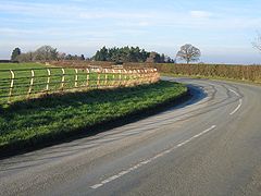
Caldecott (Cheshire)
(c) John S Turner, CC BY-SA 2.0 | |
| Państwo | |
|---|---|
| Kraj | |
| Hrabstwo ceremonialne | Cheshire |
| Unitary authority | Cheshire West and Chester |
| Populacja (2001) • liczba ludności | 24 |
| Nr kierunkowy | 01829 |
| Kod pocztowy | CH3 |
Położenie na mapie Cheshire Contains Ordnance Survey data © Crown copyright and database right, CC BY-SA 3.0 | |
Położenie na mapie Wielkiej Brytanii (c) Karte: NordNordWest, Lizenz: Creative Commons by-sa-3.0 de | |
| Portal | |
Caldecott – wieś w Anglii, w hrabstwie ceremonialnym Cheshire, w dystrykcie (unitary authority) Cheshire West and Chester. Leży 16 km na południe od miasta Chester i 253 km na północny zachód od Londynu[1]. W 2001 miejscowość liczyła 24 mieszkańców.
Przypisy
- ↑ Caldecott na mapie (ang.). getamap.ordnancesurvey.co.uk. [dostęp 2010-10-06].
Media użyte na tej stronie
(c) Karte: NordNordWest, Lizenz: Creative Commons by-sa-3.0 de
Location map of the United Kingdom
Flag of England. Saint George's cross (a red cross on a white background), used as the Flag of England, the Italian city of Genoa and various other places.
Contains Ordnance Survey data © Crown copyright and database right, CC BY-SA 3.0
Map of Cheshire, UK with the following information shown:
- Administrative borders
- Coastline, lakes and rivers
- Roads and railways
- Urban areas
Equirectangular map projection on WGS 84 datum, with N/S stretched 165%
Geographic limits:
- West: 3.15W
- East: 1.95W
- North: 53.50N
- South: 52.94N
(c) John S Turner, CC BY-SA 2.0
Corner in the Road near Caldecott Hall. At one time these metal fences, common throughout Cheshire and presumably from the post war period, would have been kept in good condition and painted white. The effects of time and often wayward vehicles is slowly causing them to disappear. Caldecott Hall is hidden in the clump of trees ahead and the footpath to Castletown Farm begins just out of sight on the right hand side of the corner.


