Camden Road
| ||
 Budynek stacji | ||
| Państwo | ||
| Miejscowość | Londyn | |
| Lokalizacja | London Borough of Camden | |
| Zarządca | ||
| Dane techniczne | ||
| Liczba peronów | 2 | |
| Linie kolejowe | ||
| ||
Położenie na mapie gminy Camden  Contains Ordnance Survey data © Crown copyright and database right, CC BY-SA 3.0 | ||
Położenie na mapie Wielkiej Brytanii  (c) Karte: NordNordWest, Lizenz: Creative Commons by-sa-3.0 de | ||
Położenie na mapie Anglii  | ||
Położenie na mapie Wielkiego Londynu  Contains Ordnance Survey data © Crown copyright and database right, CC BY-SA 3.0 | ||
| Portal | ||
Camden Road – stacja kolejowa w Londynie, na terenie London Borough of Camden, zarządzana i obsługiwana przez London Overground[1] jako część North London Line. Leży w bliskim sąsiedztwie stacji metra Camden Town, co daje możliwość dogodnych przesiadek. W roku statystycznym 2006/07 ze stacji skorzystało ok. 2 mln pasażerów[2].
Galeria

Wejście na stację
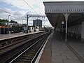
Perony

Bramki biletowe i kasa

Tablica z nazwą stacji w barwach London Overground
Przypisy
- ↑ National Rail Enquiries - Station Facilities for Camden Road. [dostęp 2011-01-06].
- ↑ Dane: Office for Rail Regulation [dostęp 2011-01-06]
| Gospel Oak – Barking |
|
|---|---|
| North London Line |
|
| South London Line |
|
| Watford DC Line | |
| West London Line |
|
| East London Line |
![]()
Media użyte na tej stronie
(c) Karte: NordNordWest, Lizenz: Creative Commons by-sa-3.0 de
Location map of the United Kingdom

Contains Ordnance Survey data © Crown copyright and database right, CC BY-SA 3.0
Blank map of the London Borough of Camden, showing electoral wards.
Equirectangular map projection on WGS 84 datum, with N/S stretched 160%
Geographic limits:
- West: 0.22W
- East: 0.10W
- North: 51.58N
- South: 51.51N
This is a logo owned by Transport for London for London Overground.

Autor: Sunil060902, Licencja: CC BY-SA 3.0
Camden Road station platforms looking east. This is one of the change-over points between AC and DC electrification along the North London Line route (AC west, DC east of here), though both systems are available on the link to the West Coast Main Line via the site of Primrose Hill. Camden Road once had four platforms, but the northern pair of tracks were lifted many years ago.
Contains Ordnance Survey data © Crown copyright and database right, CC BY-SA 3.0
Map of Greater London, UK with the following information shown:
- Administrative borders
- Coastline, lakes and rivers
- Roads and railways
- Urban areas
The data includes both primary routes and railway lines.
Equirectangular map projection on WGS 84 datum, with N/S stretched 160%
Geographic limits:
- West: 0.57W
- East: 0.37E
- North: 51.72N
- South: 51.25N

Autor: Caroline Ford, Licencja: CC-BY-SA-3.0
Camden Road railway station, London

Autor: Oxyman, Licencja: CC BY 2.5
Camden Road railway station, Ticket Office

Autor: Sunil060902, Licencja: CC BY-SA 3.0
Camden Road station platform signage, in Overground colours (temporary, as of summer 2008)