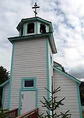
Cerkiew św. Mikołaja w Seldovii
| cerkiew parafialna | |||||||||||||
 Fasada cerkwi | |||||||||||||
| Państwo | |||||||||||||
|---|---|---|---|---|---|---|---|---|---|---|---|---|---|
| Miejscowość | |||||||||||||
| Wyznanie | |||||||||||||
| Kościół | |||||||||||||
| Parafia | |||||||||||||
| Wezwanie | |||||||||||||
| Wspomnienie liturgiczne | 9/22 maja | ||||||||||||
| |||||||||||||
| |||||||||||||
| 59°25′49″N 151°42′40″W/59,430300 -151,711000 | |||||||||||||
Cerkiew św. Mikołaja – prawosławna parafialna cerkiew w Seldovii.
Rosyjscy misjonarze prawosławni dotarli do Seldovii ok. 1820, jednak obecna świątynia jest znacznie młodsza – powstała w 1891, uzyskując natychmiast status parafialnej. Do tego momentu wspólnota wiernych z Seldovii podlegała parafii w Kenai. W 1981 drewniany budynek był remontowany z funduszy stanu Alaska.
Cerkiew w Seldovii jest w całości wzniesiona z drewna, jednonawowa, z dzwonnicą usytuowaną ponad przedsionkiem. Budynek jest malowany na biało z zielonymi obramowaniami ścian.
Bibliografia
- Seldovia Churches. seldovia.com. [zarchiwizowane z tego adresu (2010-11-28)].
Media użyte na tej stronie
The flag of Navassa Island is simply the United States flag. It does not have a "local" flag or "unofficial" flag; it is an uninhabited island. The version with a profile view was based on Flags of the World and as a fictional design has no status warranting a place on any Wiki. It was made up by a random person with no connection to the island, it has never flown on the island, and it has never received any sort of recognition or validation by any authority. The person quoted on that page has no authority to bestow a flag, "unofficial" or otherwise, on the island.
Autor: Alexrk2, Licencja: CC BY 3.0
Location map of Alaska, USA
Equirectangular projection, N/S stretching 210.0 %. Geographic limits of the map:
- N: 72.0° N
- S: 51.0° N
- W: 172.0° E
- E: 129.0° W
Autor: Uwe Dedering, Licencja: CC BY-SA 3.0
Location map of North America with national borders.
- Projection: Lambert azimuthal equal-area projection.
- Area of interest:
- N: 90.0° N
- S: 5.0° N
- W: -140.0° E
- E: -60.0° E
- Projection center:
- NS: 47.5° N
- WE: -100.0° E
- GMT projection: -JA-100/47.5/20.0c
- GMT region: -R-138.3726888474925/-3.941007863604182/2.441656573833029/50.63933645705661r
- GMT region for grdcut: -R-220.0/-4.0/20.0/90.0r
- Made with Natural Earth. Free vector and raster map data @ naturalearthdata.com.
Interior of a Russian Orthodox Church in Seldovia, Alaska. Russian Orthodox churches are typically richly decorated with gold icons and numerous religious symbols. Even in the smallest port communities, the churches are lavishly decorated. Russian Orthodox churches are found in a dozen port communities and include Unalaska, Kodiak, Seldovia, Juneau, and Sitka, to name a few. These churches continue to have active congregations and are a rare glimpse into Russian-American culture that began in the late 1700's. All churches offer cultural tours.
Autor: Izik, Licencja: CC BY 2.0
St. Nicholas Russian Orthodox Church, Seldovia, Alaska


