Chagford
 Ulica Chagford | |
| Państwo | |
|---|---|
| Kraj | |
| Region | South West |
| Hrabstwo | Devon |
| Dystrykt | West Devon |
| Populacja (2011) • liczba ludności | 1449 |
| Nr kierunkowy | 01647 |
| Kod pocztowy | TQ13 |
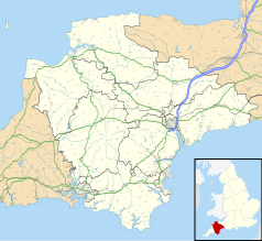
Położenie na mapie Devonu Contains Ordnance Survey data © Crown copyright and database right, CC BY-SA 3.0 | |
Położenie na mapie Wielkiej Brytanii (c) Karte: NordNordWest, Lizenz: Creative Commons by-sa-3.0 de | |
| Strona internetowa | |
| Portal | |
Chagford – miasto w Wielkiej Brytanii, w Anglii, w regionie South West, w hrabstwie Devon, w dystrykcie West Devon[1]. W 2011 r. civil parish to na powierzchni 30,3 km² zamieszkiwało 1449 osób[2]. Chagford jest wspomniana w Domesday Book (1086) jako Cageford/Chageford/Cagefort/Kagefort[3].
Miasta partnerskie
Przypisy
- ↑ Chagford (ang.). Ordnance Survey linked data. [dostęp 2016-10-28].
- ↑ Area: Chagford (Parish) (ang.). Neighbourhood Statistics (ONS). [dostęp 2016-10-28]. [zarchiwizowane z tego adresu (2016-10-28)].
- ↑ Devonshire C-D (ang.). The Domesday Book online. [dostęp 2016-10-28].
Media użyte na tej stronie
(c) Karte: NordNordWest, Lizenz: Creative Commons by-sa-3.0 de
Location map of the United Kingdom
Flag of England. Saint George's cross (a red cross on a white background), used as the Flag of England, the Italian city of Genoa and various other places.
Autor: Brian Snelson from Hockley, Essex, England, Licencja: CC BY 2.0
Inside you'll find a warren of little rooms piled high with treasures - worth a trip to the town just to see them. The word is that if they don't have what you're looking for, they'll get it - anything!
Contains Ordnance Survey data © Crown copyright and database right, CC BY-SA 3.0
Map of Devon, UK with the following information shown:
- Administrative borders
- Coastline, lakes and rivers
- Motorways and primary routes
- Urban areas
Equirectangular map projection on WGS 84 datum, with N/S stretched 150%
Geographic limits:
- West: 4.72W
- East: 2.86W
- North: 51.3N
- South: 50.16N


