Charente-Maritime
| Departament | |||||
La Rochelle – prefektura departamentu Charente-Maritime | |||||
| |||||
| Dewiza: Ouvre de nouveaux horizons (Otwórz się na nowe horyzonty) | |||||
| Państwo | |||||
|---|---|---|---|---|---|
| Region | |||||
| Prefektura | |||||
| Kod ISO 3166-2 | FR-17 | ||||
| Powierzchnia | 6 864 km² | ||||
| Populacja (2010[1]) • liczba ludności |
| ||||
| • gęstość | 90 os./km² | ||||
| Szczegółowy podział administracyjny | |||||
| Liczba podprefektur | 5 | ||||
| Liczba kantonów | 51 | ||||
| Liczba gmin | 472 | ||||
Położenie na mapie | |||||
| Portal | |||||
Charente-Maritime – departament leżący na zachodnim wybrzeżu Francji. Utworzony podczas rewolucji francuskiej 4 marca 1790. W 1941 przemianowany na Charente-Maritime. Nazwę zawdzięcza rzece Charente oraz położeniu nad oceanem.

Administracyjnie należy do regionu Nowa Akwitania (do 2015 roku Poitou-Charentes). Departament jest podzielony na pięć okręgów zwanych arrondissements (numer 17 w numeracji francuskich departamentów)[2].
Charente-Maritime jest drugim co do powierzchni departamentem regionu Poitou-Charentes. Jest też jedynym departamentem tego regionu, który ma dostęp do oceanu. Ma bardzo urozmaiconą linię brzegową. Departament znajduje się przy największym estuarium w Europie zachodniej, Żyrondzie. Przez Charente-Maritime płynie wiele rzek; najdłuższą jest Charente.
Charente-Maritime jest najbardziej zaludnionym departamentem regionu Poitou-Charentes. Nie ma w nim dużych ośrodków miejskich, które miałyby cechy aglomeracji, jednak są tam mniej zrównoważone sieci średnich i mniejszych miast, z których głównymi są La Rochelle, Saintes, Rochefort i Royan.
W gospodarce podstawową rolę odgrywa zróżnicowane rolnictwo oraz hodowle skorupiaków, największe we Francji. W Charente-Maritime nigdy nie było wielkich ośrodków przemysłowych. Wiodącym sektorem gospodarki stały się usługi. Prawie trzy czwarte miejsc pracy zajmowane są przez sklepy, administrację, usługi finansowe, zaawansowane usługi i turystykę. Turystyka jest najbardziej dynamicznie rozwijającym się segmentem gospodarki.
Prefektura Charente-Maritime mieści się w 77-tysięcznym mieście La Rochelle. Miasto to znane jest m.in. z powieści Aleksandra Dumasa Trzej Muszkieterowie.
Produktem regionalnym tego departamentu jest omułek jadalny (Mytilus edulis).
Główne miasta
(Według spisu ludności INSEE z 2006):
| Miasto | Liczba mieszk. |
|---|---|
| La Rochelle | 77 196 |
| Saintes | 26 531 |
| Rochefort | 26 299 |
| Royan | 18 202 |
| Aytré | 8687 |
| Saint-Jean-d’Angély | 7424 |
| Lagord | 6986 |
| Tonnay-Charente | 6960 |
| Périgny | 6623 |
| Saujon | 6281 |
| Saint-Pierre-d’Oléron | 6177 |
| Surgères | 5982 |
| Châtelaillon-Plage | 5911 |
| Nieul-sur-Mer | 5608 |
| Dompierre-sur-Mer | 5275 |
| Marennes | 5237 |
| Saint-Georges-de-Didonne | 5059 |
| Puilboreau | 4990 |
| Marans | 4654 |
| La Tremblade | 4499 |
Turystyka
Dobre warunki klimatyczne, znaczące dziedzictwo architektoniczne i środowiskowe, ciekawe życie kulturalne oraz różnorodna linia brzegowa (atrakcyjne wybrzeże, wyspy) powoduje, że Charente-Maritime jest największym ośrodkiem turystycznym Francji na wybrzeżu Atlantyku, oraz drugim najważniejszym w całej Francji, po Lazurowym Wybrzeżu.

La Rochelle i Stary Port

Zamek Rochecourbon

Kościół Sainte-Radegonde w Talmont-sur-Gironde
Kościół w Aulnay

Zoo de la Palmyre w Les Mathes

Latarnia Coubre w la Tremblade
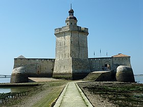
Fort Louvois między île d’Oléron, a Bourcefranc-le-Chapus

Zobacz też
- podział administracyjny Francji
- regiony i departamenty Francji
- Gminy departamentu Charente-Maritime
Linki zewnętrzne
- oficjalna strona departamentu (fr.). charente-maritime.org. [zarchiwizowane z tego adresu (2010-04-07)].
Przypisy
- ↑ INSEE: Populations légales 2010 pour les départements et les collectivités d'outre-mer. [dostęp 2013-09-07]. (fr.).
- ↑ Chiffres clés. [dostęp 2013-11-17]. [zarchiwizowane z tego adresu (2014-02-15)]. (fr.).
| Charente (16) | |
|---|---|
| Charente-Maritime (17) | |
| Corrèze (19) | |
| Creuse (23) | |
| Deux-Sèvres (79) | |
| Dordogne (24) | |
| Haute-Vienne (87) | |
| Landy (40) | |
| Lot i Garonna (47) | |
| Pireneje Atlantyckie (64) | |
| Vienne (86) | |
| Żyronda (33) |

Media użyte na tej stronie
.svg)


La Rochelle, entrée du Vieux Port

(c) Photo: JLPC / Wikimedia Commons, CC BY-SA 3.0
This building is indexed in the base Mérimée, a database of architectural heritage maintained by the French Ministry of Culture, under the reference PA00105279


Autor: Oryginalnym przesyłającym był Pep.per z francuskiej Wikipedii, Licencja: CC BY-SA 1.0
Surgères - Jardins devant la mairie - Charente-Maritime

Autor: Propre travail, Licencja: CC BY-SA 2.5
Arch of Germanicus in Saintes, Charente-Maritime, France. CIL XIII 1036 = AE 1980, 626:
A: Germanico [Caesa]r[i] Ti(beri) Aug(usti) f(ilio)/ divi Augusti nep(oti) divi Iuli pronep(oti) auguri/ flam(ini) August(ali) co(n)s
B: C(aius) Iulius C(ai) Iuli Catuaneuni f(ilius) Rufus [C(ai) Iul(i) Agedomopatis nepos Epotsorovidi pronep(os) Volt(inia)]/ sacerdos Romae and Augusti ad aram [quae est ad Conflu Translate: “A: Germanicus Caesar Tiberius Augustus, son of St. Augustus, grandson of St. Julius, great-grandson of the augur flamen of Augustal consul the augur was consulted by the pontiff.
B: Caius Julius Catuaneunus son of Rufus of Agedomopatus grandson of Epotsorovius grandson of Voltinia priest of Rome and Augustus at the altar which is at Koblenz prefect smith of his money Caius Julius Catuaneunus son of Rufus of Agedomopates grandson of Epotsorovidius grandson of Voltinia priest of Rome and Augustus prefect of the altar at Confluence he made out of his own money.“Autor: Superbenjamin, Licencja: CC BY-SA 4.0
Blason de la région Nouvelle-Aquitaine
Autor: Marmelad, Licencja: CC BY-SA 2.5
Autogenerated image to indicate departement given by filename.

Autor: Autor nie został podany w rozpoznawalny automatycznie sposób. Założono, że to Ballista~commonswiki (w oparciu o szablon praw autorskich)., Licencja: CC-BY-SA-3.0
Photographer: User:Ballista
Autor: Autor nie został podany w rozpoznawalny automatycznie sposób. Założono, że to CaptainHaddock (w oparciu o szablon praw autorskich)., Licencja: CC-BY-SA-3.0
Description =Entrée du vieux port de la Rochelle
- Source =Photo taken by Remi Jouan
- Date =Octobre 2006
- Author =Remi Jouan

Autor: unknown, Licencja: CC-BY-SA-3.0
Rochefort. La porte du soleil, principal accès à l'ancien arsenal maritime de Rochefort. Porte de l'Arsenal (aussi appelée porte du Soleil).


(c) Jochen Jahnke, CC-BY-SA-3.0
St.-Pierre Aulnay, Chorhaupt, Querhaus, und Turm von SO


Autor: Arnaud Malon from Paris, France, Licencja: CC BY 2.0
Phare de La Coubre (Royan)


Autor: Jean Bazard, Licencja: CC BY-SA 3.0
Les remparts de Brouage: une échauguette d'angle. Brouage, Charente Maritime, France. Septembre 1936.


Autor: Serge Lacotte, Licencja: CC BY-SA 3.0
Vue générale sur la rive droite du fleuve à Tonnay-Charente (Charente-Maritime).

Autor: Patrick Despoix, Licencja: CC BY-SA 3.0
This building is classé au titre des monuments historiques de la France. It is indexed in the base Mérimée, a database of architectural heritage maintained by the French Ministry of Culture, under the reference PA00104630