Charlestown (Boston)
| Ten artykuł od 2014-04 wymaga zweryfikowania podanych informacji. |
| Dzielnica Bostonu | |
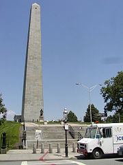
 Pomnik Bunker Hill | |
| Państwo | |
|---|---|
| Stan | |
| Hrabstwo | |
| Miasto | |
| Data założenia | 1628 |
| W granicach Bostonu | 1874 |
| Strefa numeracyjna | 617 |
| Strona internetowa | |
| Portal | |
Charlestown – dzielnica miasta Bostonu, w Stanach Zjednoczonych.
Miasto zostało założone w roku 1628. Początkowo było osobnym miastem, stolicą kolonii Massachusetts Bay. W roku 1874 zostało przyłączone do Bostonu.
Charlestown jest położone na północny wschód od centrum Bostonu, na półwyspie pomiędzy rzekami Charles i Mystic.
Jako część Bostonu wyróżnia się dużą populacją emigrantów z Irlandii.
W Charlestown urodził się wynalazca Samuel F. B. Morse oraz zmarł John Harvard, fundator Uniwersytetu Harvarda.
Linki zewnętrzne
- The community's web site. charlestownonline.net. [zarchiwizowane z tego adresu (2004-06-23)]. (ang.)
- History in pictures and maps (ang.)
Media użyte na tej stronie
Autor: Uwe Dedering, Licencja: CC BY-SA 3.0
Location map of the USA (without Hawaii and Alaska).
EquiDistantConicProjection:
Central parallel:
* N: 37.0° N
Central meridian:
* E: 96.0° W
Standard parallels:
* 1: 32.0° N
* 2: 42.0° N
Made with Natural Earth. Free vector and raster map data @ naturalearthdata.com.
Formulas for x and y:
x = 50.0 + 124.03149777329222 * ((1.9694462586094064-({{{2}}}* pi / 180))
      * sin(0.6010514667026994 * ({{{3}}} + 96) * pi / 180))
y = 50.0 + 1.6155950752393982 * 124.03149777329222 * 0.02613325650382181
      - 1.6155950752393982  * 124.03149777329222 *
     (1.3236744353715044  - (1.9694462586094064-({{{2}}}* pi / 180))
      * cos(0.6010514667026994 * ({{{3}}} + 96) * pi / 180))
The flag of Navassa Island is simply the United States flag. It does not have a "local" flag or "unofficial" flag; it is an uninhabited island. The version with a profile view was based on Flags of the World and as a fictional design has no status warranting a place on any Wiki. It was made up by a random person with no connection to the island, it has never flown on the island, and it has never received any sort of recognition or validation by any authority. The person quoted on that page has no authority to bestow a flag, "unofficial" or otherwise, on the island.
Bunker Hill Monument in Charlestown, MA, part of Boston National Historical Park.
Autor: Alexrk2, Licencja: CC BY 3.0
Location map of Massachusetts, USA
Autor: OpenStreetMap contributors, Licencja: CC BY-SA 2.0
Map of the central area of Boston and Cambridge, exported from OpenStreetMap.
Seal of Boston, Massachusetts


