Chattahoochee (rzeka)
 Rzeka Chattahoochee w systemie rzeki Apalachicola | |
| Kontynent | |
|---|---|
| Państwo | |
| Lokalizacja | |
| Rzeka | |
| Długość | 692 km |
| Powierzchnia zlewni | 22,7 tys.[1] km² |
| Średni przepływ | 286 m³/s |
| Źródło | |
| Miejsce | Blue Ridge Mountains[1] |
| Wysokość | 1082 |
| Współrzędne | |
| Ujście | |
| Miejsce | Jim Woodruff Dam |
| Wysokość | 23 |
| Współrzędne | |
Położenie na mapie Stanów Zjednoczonych  | |
Chattahoochee – rzeka w USA, w stanach Georgia i Alabama. Długość 692 km[1]. Rzeka w pobliżu tamy Jimm Woodruff łączy się z rzeką Flint tworząc, uchodzącą już do Zatoki Meksykańskiej, rzekę Apalachicola.
Rzeka Chattahoochee jest wykorzystywana w celach energetycznych. Są na niej cztery tamy tworzące następujące jeziora: Lanier (153 km²), West Point 105 km²), Walter F. George (182 km²) i Seminole (151 km²)[1].
Główne miasta nad rzeką to:
Zobacz też
Przypisy
- ↑ a b c d River BAsin Center - CHATTAHOOCHEE-FLINT RIVER BASIN (ang.). [dostęp 2012-09-03]. [zarchiwizowane z tego adresu (2010-06-09)].

Tama i jezioro West Point
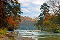
Rzeka Chattahoochee jesienią
Media użyte na tej stronie

Flag of the United States.svg
The flag of Navassa Island is simply the United States flag. It does not have a "local" flag or "unofficial" flag; it is an uninhabited island. The version with a profile view was based on Flags of the World and as a fictional design has no status warranting a place on any Wiki. It was made up by a random person with no connection to the island, it has never flown on the island, and it has never received any sort of recognition or validation by any authority. The person quoted on that page has no authority to bestow a flag, "unofficial" or otherwise, on the island.
The flag of Navassa Island is simply the United States flag. It does not have a "local" flag or "unofficial" flag; it is an uninhabited island. The version with a profile view was based on Flags of the World and as a fictional design has no status warranting a place on any Wiki. It was made up by a random person with no connection to the island, it has never flown on the island, and it has never received any sort of recognition or validation by any authority. The person quoted on that page has no authority to bestow a flag, "unofficial" or otherwise, on the island.

USACE West Point Dam and Lake.jpg
West Point Dam and Lake on the Chattahoochee River. The dam impounds West Point Lake. The dam is located near La Grange in Troup County, Georgia, USA, near the Alabama state line. The dam was constructed by the U.S. Army Corps of Engineers for flood control on the Chattahoochee River.
West Point Dam and Lake on the Chattahoochee River. The dam impounds West Point Lake. The dam is located near La Grange in Troup County, Georgia, USA, near the Alabama state line. The dam was constructed by the U.S. Army Corps of Engineers for flood control on the Chattahoochee River.

Fall-View-West-Chattahoochee-NPS.jpg
The Chattahoochee River in Autumn
The Chattahoochee River in Autumn
Usa edcp relief location map.png
Autor: Uwe Dedering, Licencja: CC BY-SA 3.0
Relief location map of the USA (without Hawaii and Alaska).
Autor: Uwe Dedering, Licencja: CC BY-SA 3.0
Relief location map of the USA (without Hawaii and Alaska).
EquiDistantConicProjection : Central parallel :
* N: 37.0° N
Central meridian :
* E: 96.0° W
Standard parallels:
* 1: 32.0° N
* 2: 42.0° N
Made with Natural Earth. Free vector and raster map data @ naturalearthdata.com.
Formulas for x and y:
x = 50.0 + 124.03149777329222 * ((1.9694462586094064-({{{2}}}* pi / 180))
      * sin(0.6010514667026994 * ({{{3}}} + 96) * pi / 180))
y = 50.0 + 1.6155950752393982 * 124.03149777329222 * 0.02613325650382181
      - 1.6155950752393982  * 124.03149777329222 *
     (1.3236744353715044  - (1.9694462586094064-({{{2}}}* pi / 180))
      * cos(0.6010514667026994 * ({{{3}}} + 96) * pi / 180))
Chattahoochee watershed.png
Autor: Pfly, Licencja: CC BY-SA 2.5
Map of the Chattahoochee River (highlighted) and watershed — in the Apalachicola Basin (ACF Basin)
Autor: Pfly, Licencja: CC BY-SA 2.5
Map of the Chattahoochee River (highlighted) and watershed — in the Apalachicola Basin (ACF Basin)
- Located in Georgia and Alabama, of the Southeastern United States.