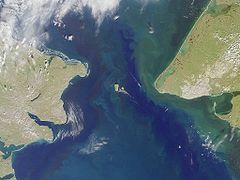
Cieśnina Beringa
 Cieśnina Beringa | |
| Państwo | |
|---|---|
| Rodzaj obiektu | |
Cieśnina Beringa (ang. Bering Strait, ros. Берингов пролив – Bieringow proliw) – cieśnina między Azją a Ameryką Północną. Cieśnina łączy Morze Czukockie z Morzem Beringa, czyli Ocean Arktyczny z Oceanem Spokojnym. Jej szerokość wynosi około 85 km, a głębokość od 30 do 50 m[1].
Przylądki
Po rosyjskiej stronie cieśniny znajduje się Przylądek Dieżniowa, część Półwyspu Czukockiego, po amerykańskiej Przylądek Księcia Walii na Półwyspie Seward[2][3].
Wyspy
Pośrodku cieśniny położone są dwie wyspy: rosyjska Wyspa Ratmanowa i należąca do Stanów Zjednoczonych – Little Diomede Island.
Linia zmiany daty
Pomiędzy tymi wyspami przebiega linia zmiany daty i granica między Stanami Zjednoczonymi a Rosją.
Historia
Cieśnina odkryta pierwszy raz przez Siemiona Dieżniowa w 1648, po raz drugi w 1728 przez będącego w rosyjskiej służbie, duńskiego odkrywcę Vitusa Beringa, od którego pochodzi nazwa cieśniny.
Zobacz też
- most lądowy Beringa
- tunel pod Cieśniną Beringa
Przypisy
- ↑ Bering Strait, [w:] Encyclopædia Britannica [online] [dostęp 2018-01-17] (ang.).
- ↑ Cape Prince of Wales – Westernmost point of continental North America. MOSTPOINT. [dostęp 2018-01-17]. [zarchiwizowane z tego adresu (2018-01-17)]. (ang.).
- ↑ Feature Detail Report for: Cape Prince of Wales. Geographic Names Information System (GNIS). [dostęp 2018-01-17]. (ang.).
Media użyte na tej stronie
The flag of Navassa Island is simply the United States flag. It does not have a "local" flag or "unofficial" flag; it is an uninhabited island. The version with a profile view was based on Flags of the World and as a fictional design has no status warranting a place on any Wiki. It was made up by a random person with no connection to the island, it has never flown on the island, and it has never received any sort of recognition or validation by any authority. The person quoted on that page has no authority to bestow a flag, "unofficial" or otherwise, on the island.
Bering strait, image taken by MISR satellite.
With the Seward Peninsula of Alaska to the east, and Chukotskiy Poluostrovof Siberia to the west, the Bering Strait separates the United States and the Russian Federation by only 90 kilometers. It is named for Danish explorer Vitus Bering, who spotted the Alaskan mainland in 1741 while leading an expedition of Russian sailors. This view of the region was captured by MISR's vertical-viewing (nadir) camera on August 18, 2000 during Terra orbit 3562.
The boundary between the US and Russia lies between Big and Little Diomede Islands, which are visible in the middle of the Bering Strait. The Arctic Circle, at 66.5 degrees north latitude, runs through the Arctic Ocean in the top part of this image. This circle marks the southernmost latitude for which the Sun does not rise above the horizon on the day of the winter solstice. At the bottom of this image is St. Lawrence Island. Situated in the Bering Sea, it is part of Alaska and home to Yupik Eskimos.
MISR was built and is managed by NASA's Jet Propulsion Laboratory, Pasadena, CA, for NASA's Office of Earth Science, Washington, DC. The Terra satellite is managed by NASA's Goddard Space Flight Center, Greenbelt, MD. JPL is a division of the California Institute of Technology. For more information: http://www-misr.jpl.nasa.govAutor: Tentotwo, Licencja: CC BY-SA 3.0
Location map of Pacific Ocean.
- Projection: Lambert azimuthal equal-area projection.
- Area of interest:
- N: 60.0° N
- S: -80.0° N
- W: -260.0° E
- E: -70.0° E
- Projection center:
- NS: -10.0° N
- WE: -165.0° E
- GMT projection: -JA-165.0/-10.0/180/19.998266666666666c
- GMT region: -R-320.2519138145009/-12.459450078533589/-5.473602099069988/26.40516525873812r
- Land and shoreline: 1:110m Natural Earth Datasets, borders 1:50m


