Columbia Center
| ||
 (c) DubbaG, CC-BY-SA-3.0 | ||
| Państwo | ||
|---|---|---|
| Miejscowość | Seattle | |
| Adres | Piąta Aleja 701 (701 Fifth Avenue) | |
| Architekt | Chester L. Lindsey | |
| Wysokość całkowita | 295 m | |
| Wysokość do dachu | 284,2 m | |
| Kondygnacje | 76 | |
| Rozpoczęcie budowy | 1982 | |
| Ukończenie budowy | 1985 | |
Położenie na mapie Waszyngtonu  | ||
Położenie na mapie Stanów Zjednoczonych  | ||
| Strona internetowa | ||
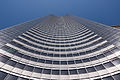
Columbia Center (inne nazwy to Bank of America Tower, Columbia Seafirst Center) – najwyższy budynek w Seattle. Wieżowiec został zaprojektowany przez Chestera L. Lindseya. Rozpoczęta w roku 1982 budowa trwała 3 lata, po jej ukończeniu 295-metrowy wieżowiec był najwyższym budynkiem po zachodniej stronie rzeki Missisipi, drugim co do wielkości na Zachodnim Wybrzeżu oraz dwunastym w całym USA. W budynku mieści się 76 kondygnacji o zagospodarowaniu biurowym oraz 7 pod ziemią, służących głównie za parkingi.
U podstaw budynek jest wyłożony granitem, co nadaje mu elegancki wygląd. Struktura budynku opiera się na trzech łukach, dzięki temu wygląda jak trzy wieże stojące jedna obok drugiej. Pierwotnie wysokość budynku miała wynosić 306,5 m. jednak Federalna Administracja Lotnictwa Cywilnego Stanów Zjednoczonych nie wydała zezwolenia na budowę tak wysokiego wieżowca w pobliżu portu lotniczego Sea-Tac.
Na początku budynek nazywał się Columbia Center, jednak nazwa została zmieniona przez Seafirst Bank na Columbia Seafirst Center. Wkrótce po tym Bank of America, który był macierzystym bankiem Seafirst Bank zmienił nazwę budynku na Bank of America Tower. Ostatecznie jednak, w listopadzie 2005 r. nazwa została z powrotem zmieniona na Columbia Center.
16 czerwca 2004 Krajowa Komisja ds. Ataków Terrorystycznych na Stany Zjednoczone (9/11 Commision) doniosła, że pierwotnym planem terrorystów którzy wykonali 11 września 2001 r. Zamach na World Trade Center i Pentagon było rozbicie samolotów „o najwyższe budynki stanów Kalifornia i Waszyngton”, którymi mogły być Columbia Center i U.S. Bank Tower.
Galeria

Columbia Center

Widok na Bank of America Tower
Columbia Center wieczorem

Space Needle z tarasu widokowego

Downtown Seattle z tarasu widokowego

Pod Columbia Center

Panorama z tarasu widokowego
Zobacz też
- lista najwyższych budynków na świecie
- lista najwyższych budynków w Stanach Zjednoczonych
- lista najwyższych budynków w Seattle
Media użyte na tej stronie
Autor: Alexrk2, Licencja: CC BY 3.0
Ta mapa została stworzona za pomocą GeoTools.
Autor: Uwe Dedering, Licencja: CC BY-SA 3.0
Location map of the USA (without Hawaii and Alaska).
EquiDistantConicProjection:
Central parallel:
* N: 37.0° N
Central meridian:
* E: 96.0° W
Standard parallels:
* 1: 32.0° N
* 2: 42.0° N
Made with Natural Earth. Free vector and raster map data @ naturalearthdata.com.
Formulas for x and y:
x = 50.0 + 124.03149777329222 * ((1.9694462586094064-({{{2}}}* pi / 180))
      * sin(0.6010514667026994 * ({{{3}}} + 96) * pi / 180))
y = 50.0 + 1.6155950752393982 * 124.03149777329222 * 0.02613325650382181
      - 1.6155950752393982  * 124.03149777329222 *
     (1.3236744353715044  - (1.9694462586094064-({{{2}}}* pi / 180))
      * cos(0.6010514667026994 * ({{{3}}} + 96) * pi / 180))

The flag of Navassa Island is simply the United States flag. It does not have a "local" flag or "unofficial" flag; it is an uninhabited island. The version with a profile view was based on Flags of the World and as a fictional design has no status warranting a place on any Wiki. It was made up by a random person with no connection to the island, it has never flown on the island, and it has never received any sort of recognition or validation by any authority. The person quoted on that page has no authority to bestow a flag, "unofficial" or otherwise, on the island.

Columbia Center and nearby buldings
Autor: Alexrk2, Licencja: CC BY 3.0
Ta mapa została stworzona za pomocą GeoTools.

Autor: User:Nova77, Licencja: CC-BY-SA-3.0
Bank of America Tower (later Columbia Center) in Seattle, taken by Nova77 in summer 2002.

Autor: Vmenkov, Licencja: CC-BY-SA-3.0
Seattle Center, Space Needle, Puget Sound, and Queen Anne Hill (top right of photo) seen from the observation deck of the Columbia Center (former Bank of America Tower).

Autor: Vmenkov, Licencja: CC-BY-SA-3.0
A view of Seattle looking north from the observation deck of Columbia Center. Northern part of downtown, Space Needle, and Magnolia can be seen.)

Autor: Ikiwaner, Licencja: CC-BY-SA-3.0
Columbia Center in Seattle, WA, USA

Autor: Rahula59, Licencja: CC BY-SA 3.0
Panorama shot at the 73rd floor of the Columbia Center (formerly Bank of America Tower) in down-town Seattle.