Columbia Mountains
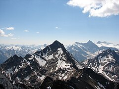
 Widok na łańcuch gór Cariboo | |
| Kontynent | |
|---|---|
| Państwo | |
| Najwyższy szczyt | Mount Sir Sandford[1] |
| Długość | 741[2] km |
| Powierzchnia | 135 952[2] km² |
| Jednostka dominująca | |
 Położenie Gór Columbia na mapie Kanady i USA | |
| 51,6567°N 117,8680°W/51,656700 -117,868000 | |
Columbia Mountains – łańcuch górski w Kanadzie i Stanach Zjednoczonych należący do systemu Kordylierów[3]. Geografowie USA zaliczają go do Gór Skalistych. Największa część gór znajduje się w kanadyjskiej prowincji Kolumbia Brytyjska (75%), a kolejne są już Stanach Zjednoczonych: Waszyngton (17%), Idaho (5%) i Montana (3%)[2].
Columbia Mountains dzieli się na pasma:
- Cariboo Mountains,
- Shuswap Highland,
- Okanogan Highlands,
- Monashee Mountains,
- Selkirk Mountains,
- Purcell Mountains.
Naturalne granice Columbia Mountains tworzą: od wschodu główna grań Gór Skalistych, od południa rzeka Kolumbia, od północy rzeka Fraser, a od zachodu Interior Plateau (Płaskowyż Wewnętrzny)[4].
Najwyższe szczyty
- Mount Sir Sandford - 3519 m n.p.m., pasmo Selkirk
- Mount Sir Wilfrid Laurier - 3516 m n.p.m., Cariboo Mountains
- Mount Farnham - 3493 m n.p.m., Purcell Mountains
- Mount Jumbo - 3437 m n.p.m., Purcell Mountains
- Howser Spire - 3412 m n.p.m., Purcell Mountains
- Karnak Mountain - 3411 m n.p.m., Purcell Mountains
- Mount Delphine - 3406 m n.p.m., Purcell Mountains
- Mount Sir John Abbott - 3398 m n.p.m., Cariboo Mountains
- Mount Hammond - 3387 m n.p.m., Purcell Mountains
- Mount Dawson - 3377 m n.p.m., Selkirk
Przypisy
- ↑ Mount Sir Sandford, British Columbia. Peakbagger.org. [dostęp 2016-03-03]. (ang.).
- ↑ a b c Columbia Mountains. Peakbagger.com. [dostęp 2016-03-04]. (ang.).
- ↑ Geology of the Canadian Rockies and Columbia Mountains. [dostęp 2016-03-04]. (ang.).
- ↑ Columbia Mountains, [w:] Encyclopædia Britannica [online] [dostęp 2016-03-04] (ang.).
Media użyte na tej stronie
The flag of Navassa Island is simply the United States flag. It does not have a "local" flag or "unofficial" flag; it is an uninhabited island. The version with a profile view was based on Flags of the World and as a fictional design has no status warranting a place on any Wiki. It was made up by a random person with no connection to the island, it has never flown on the island, and it has never received any sort of recognition or validation by any authority. The person quoted on that page has no authority to bestow a flag, "unofficial" or otherwise, on the island.
Black up-pointing triangle ▲, U+25B2 from Unicode-Block Geometric Shapes (25A0–25FF)
Autor: Uwe Dedering, Licencja: CC BY-SA 3.0
Relief location map of North America.
- Projection: Lambert azimuthal equal-area projection.
- Area of interest:
- N: 90.0° N
- S: 5.0° N
- W: -140.0° E
- E: -60.0° E
- Projection center:
- NS: 47.5° N
- WE: -100.0° E
- GMT projection: -JA-100/47.5/20.0c
- GMT region: -R-138.3726888474925/-3.941007863604182/2.441656573833029/50.63933645705661r
- GMT region for grdcut: -R-220.0/-4.0/20.0/90.0r
- Relief: SRTM30plus.
- Made with Natural Earth. Free vector and raster map data @ naturalearthdata.com.
Autor: Rufus Hawthorne, Licencja: CC BY-SA 3.0
Peaks of the Premier Range, Cariboo Mountains, from the summit of Mica Mountain, British Columbia. Mt Arthur Meighan in distance at right.
adapted from File:South BC-NW USA-relief.png already in Wikimedia Commons.


