Dampremy
| Ten artykuł od 2022-08 wymaga zweryfikowania podanych informacji. |
| Dzielnica Charleroi | |||
 Dawny ratusz | |||
| |||
| Państwo | |||
|---|---|---|---|
| Miasto | |||
| W granicach Charleroi | od 1977 | ||
| Powierzchnia | 2,77 km² | ||
| Populacja (2001) • liczba ludności |
| ||
Położenie na mapie Charleroi | |||
Dampremy - część miasta Charleroi, do 1977 samodzielna gmina. Populacja w 2001 wynosiła 8,566 mieszkańców.
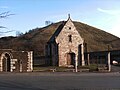
Kaplica Saint-Ghislain.
Media użyte na tej stronie
.svg)

Dampremy-Chapelle Saint-Ghislain-1.jpg
Dampremy (Charleroi - Belgique), Chapelle Saint-Ghislain (choeur de l'ancienne église)
Dampremy (Charleroi - Belgique), Chapelle Saint-Ghislain (choeur de l'ancienne église)

Blason ville be Dampremy.svg
Autor: Jmh2o, Licencja: CC BY-SA 4.0
Blason (non officiel) de Dampremy (Charleroi-Belgique) : D'argent à la fasce de gueules, chargée d'une divise vivrée d'or
Autor: Jmh2o, Licencja: CC BY-SA 4.0
Blason (non officiel) de Dampremy (Charleroi-Belgique) : D'argent à la fasce de gueules, chargée d'une divise vivrée d'or

Map Dampremy in Charleroi.svg
Autor: Jmh2o, Licencja: CC BY-SA 3.0
Localisation de Dampremy dans la commune de Charleroi (Belgique)
Autor: Jmh2o, Licencja: CC BY-SA 3.0
Localisation de Dampremy dans la commune de Charleroi (Belgique)
Dampremy - château Passelecq - ancien Hôtel de ville - 2018 - 01.jpg
Autor: Jmh2o, Licencja: CC BY-SA 4.0
Dampremy (Charleroi-Belgium) - Directorial castle of the Sacré-Madame coal mines built at the end of the 19th century in neoclassical style. It is called Passelecq then Roisin from the name of successive directors before becoming the town hall of Dampremy and finally being occupied by municipal services of the City of Charleroi.