De Koog
| Ten artykuł od 2013-05 wymaga zweryfikowania podanych informacji. |
 zdjęcie lotnicze wsi | |
| Państwo | |
|---|---|
| Prowincja | |
| Gmina | |
| Populacja • liczba ludności |
|
Położenie na mapie Holandii Północnej  | |
Położenie na mapie Holandii  | |
| Strona internetowa | |
De Koog – wieś w Holandii w gminie Texel w prowincji Holandia Północna. Liczy około 1300 mieszkańców.
De Koog leży w zachodniej części wyspy Texel, niemal nad samym brzegiem Morza Północnego. Gospodarka miejscowości opiera się przede wszystkim na turystyce (liczne hotele, bary, kawiarnie i kluby). Zanim De Koog stało się nadmorskim kurortem było wsią rybacką. Najstarszymi zachowanymi zabytkami w De Koog są kościół z 1415 roku oraz stojący obok niego dom.
Galeria
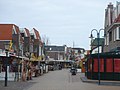
Główna ulica we wsi
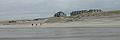
plaża

Grand Hotel Opduin

wieś (na pierwszym planie pozostałości starego cmentarz)

kościół
Linki zewnętrzne
- Oficjalna strona wsi. dekoogbadplaats.nl. [zarchiwizowane z tego adresu (2006-08-31)].
- Ecomare.nl
Media użyte na tej stronie


Opduin2007.jpg
Opduin "nu"
Opduin "nu"
Netherlands North Holland location map.svg
Autor: Erik Frohne, Licencja: CC BY-SA 3.0
Location map of province North Holland in the Netherlands
Autor: Erik Frohne, Licencja: CC BY-SA 3.0
Location map of province North Holland in the Netherlands
Equirectangular projection, N/S stretching 165 %. Geographic limits of the map:
- N: 53.20° N
- S: 52.10° N
- W: 4.30° E
- E: 5.40° E

Church in de koog.JPG
The only church in De Koog, on the island Texel (Netherlands)
The only church in De Koog, on the island Texel (Netherlands)

De Koog Beach 2.jpg
Autor: Traitor, Licencja: CC BY-SA 3.0
Beach of De Koog on the island of Texel, Netherlands.
Autor: Traitor, Licencja: CC BY-SA 3.0
Beach of De Koog on the island of Texel, Netherlands.


De Koog.jpg
Autor: Traitor, Licencja: CC BY-SA 3.0
Main shopping street of De Koog on the island of Texel, Netherlands.
Autor: Traitor, Licencja: CC BY-SA 3.0
Main shopping street of De Koog on the island of Texel, Netherlands.