Dhemaji (dystrykt)
| Dystrykt | |
 | |
| Państwo | |
|---|---|
| Stan | |
| Siedziba | Dhemaji |
| Powierzchnia | 3 237 km² |
| Populacja (2001) • liczba ludności |
|
| • gęstość | 176 os./km² |
Położenie na mapie | |
| Strona internetowa | |
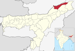
Dhemaji – jeden z dwudziestu siedmiu dystryktów administracyjnych w stanie Asam w północno-wschodnich Indiach[1], położony w północno-wschodniej części stanu. Stolicą dystryktu jest miasto Dhemaji. Powierzchnia dystryktu to 3 237 km²[2], a populacja wyniosła 571 944 osób, w 2001 roku. Większa część mieszkańców mieszka na wsi, a ludność miejską stanowi 1,85% populacji. 41,69% potrafi czytać i pisać, z czego 13,6% kobiet. Główne religie wśród ludności dystryktu to: hinduizm 548 780, islam 10 533 (1.84%) oraz chrześcijaństwo 6 390.
Geografia
Dhemaji jest jednym z najmłodszych dystryktów w stanie Asam. Powstał 1 października 1989. Jest jednym z najbardziej wysuniętych na północ dystryktów Indii. Jest usytuowany na przedgórzu Małych Himalajów. Stolica stanu, Dhemaji, jest relatywnie małym miastem. Jego nazwa prawdopodobnie pochodzi od dwóch słów w języku assamskim "dhal" co oznacza "powódź" oraz "dhemali" co oznacza "gra". Ma to związek z położeniem miasta u zbiegu rzek, potężnej Brahmaputry oskrzydlającej dystrykt oraz licznych jej dopływów. Efektem takiego położenia są liczne powodzie nawiedzające region.
Dystrykt jest zamieszkały w większości przez ludność mówiącą językiem assamskim z plemion - Ahom (dawniej na tych terenach rozciągało się Królestwo Ahom), Sonowal Kacharis, Koches, Kalitas, Kaibartas oraz Mishings i Deoris. Wśród mieszkańców są także napływowi Indusi oraz bengalscy muzułmanie.
Zobacz też
Linki zewnętrzne
Przypisy
- ↑ Dystrykty stanu Asam
- ↑ Profil na stronie dystryktu. [dostęp 2010-03-06]. [zarchiwizowane z tego adresu (2009-10-06)].
Media użyte na tej stronie
The Flag of India. The colours are saffron, white and green. The navy blue wheel in the center of the flag has a diameter approximately the width of the white band and is called Ashoka's Dharma Chakra, with 24 spokes (after Ashoka, the Great). Each spoke depicts one hour of the day, portraying the prevalence of righteousness all 24 hours of it.
Autor: Own work based on User:Planemad, Licencja: CC BY 3.0
Map of Dhemaji district of Assam
Autor: Deepraj, Licencja: CC BY 2.5
Poignant view of a sunset captured from near Sukleswar ghat in Guwahati. The photograph has a wide range of saturated colours and shows two small fishing boats and framed by the hills on both sides of the Saraighat Bridge across the river Brahmaputra. The many colours of the sky are nicely reflected on the rippling water.
Autor: Map made by me, Nichalp, Licencja: CC-BY-SA-3.0
Note: The Indian state of w:Jammu and Kashmir is claimed by w:India, w:Pakistan and the w:People's Republic of China. This map depicts the boundaries of the state as it was in 1947. Areas administered by India is coloured as per the rest of the states, and the area administered by Pakistan and China are coloured in a neutral colour. See the map of Jammu and Kashmir. The Indian state of w:Arunachal Pradesh is claimed by China as a part of w:South Tibet. The claimed region is depicted in a pale shade of pink. See the map of Arunachal Pradesh. The Indian territorial waters extend to a distance of twelve nautical miles.


