Diecezja Charleston
 Katedra diecezjalna św. Jana Chrzciciela | |
| Państwo | |
|---|---|
| Siedziba | Charleston, Karolina Południowa |
| Data powołania | 1820 |
| Wyznanie | |
| Kościół | |
| Metropolia | |
| Katedra diecezjalna | Katedra św. Jana Chrzciciela w Charleston |
| Biskup diecezjalny | |
| Biskup senior | |
| Dane statystyczne (2006) | |
| Liczba wiernych | 157 358 |
| Liczba kapłanów | 140 |
| Liczba parafii | 92 |
| Powierzchnia | 80 401 km² |
| Strona internetowa | |
Diecezja Charleston (łac. Dioecesis Carolopolitana, ang. Roman Catholic Diocese of Charleston) – rzymskokatolicka diecezja ze stolicą w Charleston, w stanie Karolina Południowa, we wschodniej części Stanów Zjednoczonych.
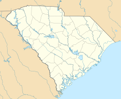
Jest częścią regionu[1] XIV (FL, GA, NC, SC) i granice diecezji pokrywają się w całości z terytorium stanu Karolina Południowa.
Diecezja powstała 11 lipca 1820 roku. Początkowo należała do metropolii Baltimore. W lutym 1962 roku została przeniesiona do nowo powstałej metropolii Atlanty, w której pozostaje do dziś. Siedzibą biskupa jest Charleston.
Arcybiskupi Charleston
- John England (1820-1842)
- Ignatius A. Reynolds (1843-1855)
- Patrick N. Lynch (1857-1882)
- Henry P. Northrop (1883-1916)
- William Thomas Russell (1916-1927)
- Emmet M. Walsh (1927 -1949)
- John J. Russell (1950-1958)
- Paul Hallinan (1958-1962)
- Francis Frederick Reh (1962-1964)
- Ernest Leo Unterkoefler (1964-1990)
- David Bernard Thompson (1990-1999)
- Robert Joseph Baker (1999-2007)
- Robert Guglielmone (2009-2022)
- Jacques Fabre (od 2022)
Wydawnictwa
- The Catholic Miscellany
Przypisy
Bibliografia
- Charleston (Diocese) Catholic-Hierarchy (ang.). [dostęp 2010-01-07].
Media użyte na tej stronie
Autor: Uwe Dedering, Licencja: CC BY-SA 3.0
Location map of the USA (without Hawaii and Alaska).
EquiDistantConicProjection:
Central parallel:
* N: 37.0° N
Central meridian:
* E: 96.0° W
Standard parallels:
* 1: 32.0° N
* 2: 42.0° N
Made with Natural Earth. Free vector and raster map data @ naturalearthdata.com.
Formulas for x and y:
x = 50.0 + 124.03149777329222 * ((1.9694462586094064-({{{2}}}* pi / 180))
      * sin(0.6010514667026994 * ({{{3}}} + 96) * pi / 180))
y = 50.0 + 1.6155950752393982 * 124.03149777329222 * 0.02613325650382181
      - 1.6155950752393982  * 124.03149777329222 *
     (1.3236744353715044  - (1.9694462586094064-({{{2}}}* pi / 180))
      * cos(0.6010514667026994 * ({{{3}}} + 96) * pi / 180))
The flag of Navassa Island is simply the United States flag. It does not have a "local" flag or "unofficial" flag; it is an uninhabited island. The version with a profile view was based on Flags of the World and as a fictional design has no status warranting a place on any Wiki. It was made up by a random person with no connection to the island, it has never flown on the island, and it has never received any sort of recognition or validation by any authority. The person quoted on that page has no authority to bestow a flag, "unofficial" or otherwise, on the island.
Japanese map symbol "Church". U+26EA
Autor: Farragutful, Licencja: CC BY-SA 3.0
The Diocese of Charleston encompasses the entire state of South Carolina, USA.
Autor: Alexrk, Licencja: CC BY 3.0
Ta mapa została stworzona za pomocą GeoTools.
Autor: Oryginalnym przesyłającym był AlanEisen z angielskiej Wikipedii, Licencja: CC BY-SA 3.0
Cathedral of St. John the Baptist, Charleston, SC. October 2011.


