Earl’s Court (stacja metra)
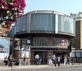
 Starsze z wejść na stację | |
| Państwo | |
|---|---|
| Kraj | |
| Miejscowość | |
| Data otwarcia | 1868 |
| District Line | |
| Poprzednia stacja | West Kensington |
| Następna stacja | |
| Piccadilly line | |
| Poprzednia stacja | |
| Następna stacja | Barons Court |
Położenie na mapie gminy Kensington and Chelsea  Contains Ordnance Survey data © Crown copyright and database right, CC BY-SA 3.0 | |
Położenie na mapie Wielkiej Brytanii  (c) Karte: NordNordWest, Lizenz: Creative Commons by-sa-3.0 de | |
Położenie na mapie Anglii  | |
Położenie na mapie Wielkiego Londynu  Contains Ordnance Survey data © Crown copyright and database right, CC BY-SA 3.0 | |
| Portal | |
Earl's Court – stacja metra londyńskiego na terenie Royal Borough of Kensington and Chelsea, leżąca na trasie dwóch linii: District Line oraz Piccadilly line[1]. Została oddana do użytku w 1869 roku[2]. W roku 2011 skorzystało z niej ok. 20,97 mln pasażerów[3]. Należy jednocześnie do pierwszej i drugiej strefy biletowej[4].
Galeria
Nowsze wejście (od zachodu) na stację
 (c) Chris McKenna (Thryduulf), CC BY-SA 4.0
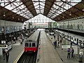
Perony naziemnej linii District
 (c) Chris McKenna (Thryduulf), CC BY-SA 4.0
Jeden z peronów głębokiej, podziemnej linii Piccadilly

Logo stacji
Przypisy
- ↑ Schemat sieci metra w Londynie. tfl.gov.uk. [zarchiwizowane z tego adresu (2008-06-26)]. [dostęp 2010-12-18]
- ↑ CULG - District Line. [dostęp 2010-12-18].
- ↑ Tube performance | Transport for London. [dostęp 2010-12-18].
- ↑ Lista stacji i stref biletowych metra londyńskiego. [dostęp 2010-12-18]. [zarchiwizowane z tego adresu (2008-06-26)].
| Linia główna |
|
|---|---|
| Odgałęzienie Wimbledon |
|
| Odgałęzienie Edgware Road | |
| Odgałęzienie Kensington (Olympia) | |
| Odgałęzienie Richmond/Ealing |
|
| Nitka Richmond |
|
| Nitka Ealing |
![]()
| Linia główna |
|
|---|---|
| Odgałęzienie Uxbridge |
|
| Odgałęzienie Heathrow |
|
![]()
Media użyte na tej stronie
(c) Karte: NordNordWest, Lizenz: Creative Commons by-sa-3.0 de
Location map of the United Kingdom
Contains Ordnance Survey data © Crown copyright and database right, CC BY-SA 3.0
Map of Greater London, UK with the following information shown:
- Administrative borders
- Coastline, lakes and rivers
- Roads and railways
- Urban areas
The data includes both primary routes and railway lines.
Equirectangular map projection on WGS 84 datum, with N/S stretched 160%
Geographic limits:
- West: 0.57W
- East: 0.37E
- North: 51.72N
- South: 51.25N


Flag of England. Saint George's cross (a red cross on a white background), used as the Flag of England, the Italian city of Genoa and various other places.
Contains Ordnance Survey data © Crown copyright and database right, CC BY-SA 3.0
Blank map of the Royal Borough of Kensington and Chelsea, showing electoral wards.
Equirectangular map projection on WGS 84 datum, with N/S stretched 160%
Geographic limits:
- West: 0.235W
- East: 0.145W
- North: 51.535N
- South: 51.475N


(c) Chris McKenna (Thryduulf), CC BY-SA 4.0
The en:District Line platforms at Earl's Court London Underground station viewed from the main concourse.
The leftmost train is an unrefurbished London Underground D78 Stock on a westbound service. The train on the far right platform is one of the refurbished D78 stock units on an eastbound service, that the platform indicators suggest is en-route to Tower Hill. The train in the centre of the picture is a London Underground C69 Stock train heading east to Edgware Road via High Street Kensington.


(c) Chris McKenna (Thryduulf), CC BY-SA 4.0
The eastbound Piccadilly Line platform at Earl's Court tube station.
Earl's Court underground station, Earls Court Road entrance (September 2006)

Earl's Court underground station, Exhibition Centre entrance (September 2006)

Autor: Sunil060902, Licencja: CC BY-SA 3.0
Earl's Court tube station District line platform roundel