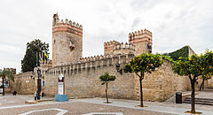
El Puerto de Santa María
| |||||
(c) Diego Delso, CC BY-SA 4.0 | |||||
| |||||
| Państwo | |||||
| Wspólnota autonomiczna | |||||
| Burmistrz | Enrique Moresco | ||||
| Powierzchnia | 159,34 km² | ||||
| Wysokość | 6 m n.p.m. | ||||
| Populacja (2008) • liczba ludności • gęstość | 86 288 541,53 os./km² | ||||
| Kod pocztowy | 11500 | ||||
| Tablice rejestracyjne | CA | ||||
| Strona internetowa | |||||
| Portal | |||||
El Puerto de Santa María – miasto portowe w południowo-zachodniej Hiszpanii, w regionie Andaluzja, prowincji Kadyks.
W mieście rozwinął się przemysł winiarski. W mieście znajduje się stacja kolejowa El Puerto de Santa María.
Rafael Alberti, poeta, urodził się i zmarł w tym mieście.
Zabytki
- XIII-wieczny zamek św. Marka (hiszp. Castillo San Marcos);
- Plaza de Toros, jedna z największych i najbardziej znanych aren korridy w Hiszpanii;
- kościół Mayor Prioral z XIII wieku, położony przy głównym placu miasta – Plaza Mayor.
Miasta partnerskie
 Brighton
 Calpe
Calpe Coral Gables
 Texcoco
Bibliografia
- Praca zbiorowa: Przewodniki Wiedzy i Życia – Sewilla i Andaluzja. Wyd. II. Warszawa: Hachette Livre Polska sp. z o.o., 2008, s. 163. ISBN 978-83-7448-633-0.
Media użyte na tej stronie
Autor: NordNordWest, Licencja: CC BY-SA 3.0
Location map of Spain
Equirectangular projection, N/S stretching 130 %. Geographic limits of the map:
- N: 44.4° N
- S: 34.7° N
- W: 9.9° W
- E: 4.8° E
Autor: Pedro A. Gracia Fajardo, escudo de Manual de Imagen Institucional de la Administración General del Estado, Licencja: CC0
Flaga Hiszpanii
Flag of England. Saint George's cross (a red cross on a white background), used as the Flag of England, the Italian city of Genoa and various other places.
The flag of Navassa Island is simply the United States flag. It does not have a "local" flag or "unofficial" flag; it is an uninhabited island. The version with a profile view was based on Flags of the World and as a fictional design has no status warranting a place on any Wiki. It was made up by a random person with no connection to the island, it has never flown on the island, and it has never received any sort of recognition or validation by any authority. The person quoted on that page has no authority to bestow a flag, "unofficial" or otherwise, on the island.
Autor: SanchoPanzaXXI, Licencja: CC BY-SA 4.0
Escudo municipal de El Puerto de Santa María (Cádiz): De azur, sobre ondas de azur y plata, el castillo de oro, aclarado de gules, sumado de la imagen de la Santísima Virgen vestida de plata, y resplandeciente de rayos del mismo metal. Corona real abierta.[1]
Autor: Ulaidh, Licencja: CC BY-SA 4.0
Bandera de la provincia de Cádiz (España)
(c) Diego Delso, CC BY-SA 4.0
Castle of San Marcos, El Puerto de Santa María, Cádiz, Spain


