Ely
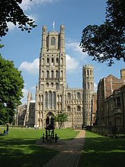
Katedra w Ely | |
| Państwo | |
|---|---|
| Kraj | |
| Region | |
| Hrabstwo | |
| Dystrykt | |
| Populacja (2001) • liczba ludności |
|
| Nr kierunkowy | 01353 |
| Kod pocztowy | CB6, CB7 |
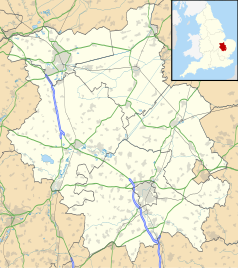
Położenie na mapie Cambridgeshire Contains Ordnance Survey data © Crown copyright and database right, CC BY-SA 3.0 | |
Położenie na mapie Wielkiej Brytanii (c) Karte: NordNordWest, Lizenz: Creative Commons by-sa-3.0 de | |
| Strona internetowa | |
| Portal | |

Ely (wym. /ˈiːli/) – miasto i civil parish w Wielkiej Brytanii, we wschodniej Anglii, w hrabstwie Cambridgeshire, dystrykcie East Cambridgeshire[1], położone w krainie historycznej Isle of Ely. W 2001 roku miasto liczyło 13 954 mieszkańców[2]. W 2011 roku civil parish liczyła 20 256 mieszkańców[3]. Ely jest wspomniane w Domesday Book (1086) jako Ely/Eli[4].
Zabytki
- romańsko-gotycka katedra z XI-XIV wieku zbudowana w miejscu klasztoru założonego w VII wieku[5] przez królową Nortumbrii św. Edeltrudę;
- pałac biskupi z XVIII wieku.
Miasta partnerskie
Zobacz też
- Ely (stacja kolejowa)
Przypisy
- ↑ Ely (ang.). Ordnance Survey linked data. [dostęp 2016-04-23].
- ↑ KS01 Usual resident population: Census 2001, Key Statistics for urban areas (ang.). Office for National Statistics. [dostęp 2016-08-03]. [zarchiwizowane z tego adresu (2004-07-23)].
- ↑ Area: Ely (Parish) (ang.). Neighbourhood Statistics (ONS). [dostęp 2016-04-23]. [zarchiwizowane z tego adresu (2016-09-27)].
- ↑ Cambridgeshire A-K (ang.). The Domesday Book online. [dostęp 2016-04-23].
- ↑ Praca zbiorowa: Sztuka Romańska. red. Rolf Toman. Tandem Verlag GmBH, 2008, s. 228. ISBN 978-83-7512-972-4.
Media użyte na tej stronie
(c) Karte: NordNordWest, Lizenz: Creative Commons by-sa-3.0 de
Location map of the United Kingdom
Flag of England. Saint George's cross (a red cross on a white background), used as the Flag of England, the Italian city of Genoa and various other places.
Autor: Oxyman, Licencja: CC BY 2.5
Oliver Cromwell lived in Ely for several years after inheriting the position of local tax collector in 1636. His former home dates to the 16th century and is now used by the Tourist Information Office as well as being a museum with rooms displayed as they would have been in Cromwell's time.
Contains Ordnance Survey data © Crown copyright and database right, CC BY-SA 3.0
Map of Cambridgeshire, UK with the following information shown:
- Administrative borders
- Coastline, lakes and rivers
- Roads and railways
- Urban areas
Equirectangular map projection on WGS 84 datum, with N/S stretched 160%
Geographic limits:
- West: 0.53W
- East: 0.55E
- North: 52.75N
- South: 51.99N
(c) Gwendraith z angielskiej Wikipedii, CC BY-SA 3.0
Ely Cathedral and Palace Green. Taken by gwendraith 3rd June 2007 {{|month=June|day=6|year=2007}}


