Epping (New Hampshire)
 | |
| Przydomek: Home of Three Governors, "The Center of the Universe" | |
| Państwo | |
|---|---|
| Stan | |
| Hrabstwo | Rockingham |
| Data założenia | 1741 |
| Kod statystyczny | FIPS: 33-24660 GNIS ID: 0873591 |
| Powierzchnia | 67,9 km² |
| Wysokość | 48 m n.p.m. |
| Populacja (2010) • liczba ludności • gęstość | 6411 94,5 os./km² |
| Nr kierunkowy | 603 |
| Kod pocztowy | 03042 |
| Strefa czasowa | UTC-05:00 UTC-04:00 |
Położenie na mapie New Hampshire  | |
Położenie na mapie Stanów Zjednoczonych  | |
| Strona internetowa | |
| Portal | |
Epping – miasteczko (town) w hrabstwie Rockingham, w stanie New Hampshire, w USA. Według danych z 2010 roku Epping zamieszkiwało niespełna 6,5 tys. osób[1].
Demografia
Liczba mieszkańców w latach
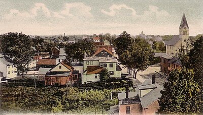
Epping z lotu ptaka (1906)
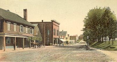
Główna ulica w Epping (1905)
Przypisy
- ↑ American FactFinder (Epping, NH) (ang.). census.gov. [dostęp 2014-11-24]. [zarchiwizowane z tego adresu (2020-02-12)].
Linki zewnętrzne
- Epping (New Hampshire) w bazie city-data.com (ang.)
- Epping town profile (ang.)
Media użyte na tej stronie
Usa edcp location map.svg
Autor: Uwe Dedering, Licencja: CC BY-SA 3.0
Location map of the USA (without Hawaii and Alaska).
Autor: Uwe Dedering, Licencja: CC BY-SA 3.0
Location map of the USA (without Hawaii and Alaska).
EquiDistantConicProjection:
Central parallel:
* N: 37.0° N
Central meridian:
* E: 96.0° W
Standard parallels:
* 1: 32.0° N
* 2: 42.0° N
Made with Natural Earth. Free vector and raster map data @ naturalearthdata.com.
Formulas for x and y:
x = 50.0 + 124.03149777329222 * ((1.9694462586094064-({{{2}}}* pi / 180))
      * sin(0.6010514667026994 * ({{{3}}} + 96) * pi / 180))
y = 50.0 + 1.6155950752393982 * 124.03149777329222 * 0.02613325650382181
      - 1.6155950752393982  * 124.03149777329222 *
     (1.3236744353715044  - (1.9694462586094064-({{{2}}}* pi / 180))
      * cos(0.6010514667026994 * ({{{3}}} + 96) * pi / 180))

Flag of the United States.svg
The flag of Navassa Island is simply the United States flag. It does not have a "local" flag or "unofficial" flag; it is an uninhabited island. The version with a profile view was based on Flags of the World and as a fictional design has no status warranting a place on any Wiki. It was made up by a random person with no connection to the island, it has never flown on the island, and it has never received any sort of recognition or validation by any authority. The person quoted on that page has no authority to bestow a flag, "unofficial" or otherwise, on the island.
The flag of Navassa Island is simply the United States flag. It does not have a "local" flag or "unofficial" flag; it is an uninhabited island. The version with a profile view was based on Flags of the World and as a fictional design has no status warranting a place on any Wiki. It was made up by a random person with no connection to the island, it has never flown on the island, and it has never received any sort of recognition or validation by any authority. The person quoted on that page has no authority to bestow a flag, "unofficial" or otherwise, on the island.
USA New Hampshire location map.svg
Autor: Alexrk2, Licencja: CC BY 3.0
Ta mapa została stworzona za pomocą GeoTools.
Autor: Alexrk2, Licencja: CC BY 3.0
Ta mapa została stworzona za pomocą GeoTools.

Bird's-eye View, Epping, NH.jpg
Bird's-eye View, Epping, NH; from a 1906 postcard.
Bird's-eye View, Epping, NH; from a 1906 postcard.

Main Street, Epping, NH.jpg
Main Street, Epping, NH; from a 1905 postcard.
Main Street, Epping, NH; from a 1905 postcard.

Leddy Building, Epping NH.jpg
Autor: John Phelan, Licencja: CC BY-SA 3.0
Leddy Building, Epping New Hampshire
Autor: John Phelan, Licencja: CC BY-SA 3.0
Leddy Building, Epping New Hampshire