Epping Forest (dystrykt)
| dystrykt niemetropolitalny | |
 | |
| Państwo | |
|---|---|
| Kraj | |
| Region | East of England |
| Hrabstwo | Essex |
| Siedziba | Epping |
| Powierzchnia | 338,99 km² |
| Populacja (2011) • liczba ludności | 124 900 |
| • gęstość | 370 os./km² |
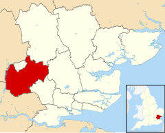
| Położenie na mapie Essex Contains Ordnance Survey data © Crown copyright and database right, CC BY-SA 3.0 | |
| Strona internetowa | |
| Portal | |
Epping Forest – dystrykt w hrabstwie Essex w Anglii.
Miasta
Inne miejscowości
Abbess Roding, Abridge, Bobbingworth, Fyfield, High Laver, High Ongar, King Street, Lower Sheering, Marden Ash, Matching Green, Matching Tye, Matching, Moreton, Nazeing, North Weald Bassett, Norton Heath, Norton Mandeville, The Rodings, Roydon, Sewardstone, Sheering, Stanford Rivers, Theydon Bois, Theydon Garnon, Theydon Mount, Thornwood Common, Upshire.
Media użyte na tej stronie
Flag of England. Saint George's cross (a red cross on a white background), used as the Flag of England, the Italian city of Genoa and various other places.
Contains Ordnance Survey data © Crown copyright and database right, CC BY-SA 3.0
Map of Essex, UK with Epping Forest highlighted.
Equirectangular map projection on WGS 84 datum, with N/S stretched 160%Autor: Acabashi, Licencja: CC BY-SA 4.0
Looking south-west on Epping High Street (the B1393 road), towards St John the Baptist Church, in Epping, Essex, England.
Software: RAW file lens-corrected, optimized and converted to JPEG with DxO OpticsPro 10 Elite, and likely further optimized and/or cropped and/or spun with Adobe Photoshop CS2.


