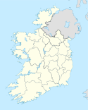
Eyrecourt
(c) Kieran Campbell, CC BY-SA 2.0 Główna ulica w Eyrecourt | |
| Państwo | |
|---|---|
| Prowincja | |
| Hrabstwo | |
| Wysokość | 55 m n.p.m. |
| Populacja (2011) • liczba ludności |
|
Eyrecourt (irl.: Dún an Uchta) – wieś w hrabstwie Galway w Irlandii położona przy drodze R365, 12 km od Banagher.
Przypisy
- ↑ Census 2011 Preliminary Report. [zarchiwizowane z tego adresu].
Media użyte na tej stronie
Main Street, Eyrecourt, Co. Galway - geograph.org.uk - 895862.jpg
(c) Kieran Campbell, CC BY-SA 2.0
Main Street, Eyrecourt, Co. Galway, near to Dun an Uchta, Fearmore, Prospect and Tully, Galway, Ireland. Large houses on the Main Street of this town which prospered in the 18th century when it was on the coach routes linking Dublin, Limerick and Galway.
(c) Kieran Campbell, CC BY-SA 2.0
Main Street, Eyrecourt, Co. Galway, near to Dun an Uchta, Fearmore, Prospect and Tully, Galway, Ireland. Large houses on the Main Street of this town which prospered in the 18th century when it was on the coach routes linking Dublin, Limerick and Galway.


