Fort Niepodległości
 Fort Niepodległości (ang. Fort Independence) | |
| Państwo | |
|---|---|
| Stan | |
| Miejscowość | Castle Island, Boston, Massachusetts |
| Ukończenie budowy | 1634 |
Położenie na mapie Massachusetts  | |
Położenie na mapie Stanów Zjednoczonych  | |
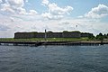
Fort Niepodległości (ang. Fort Independence) – jest zbudowaną z granitu twierdzą gwiazdą, która zapewniała ochronę Bostonowi (Massachusetts, USA). Obecnie jest chronionym parkiem stanowym USA. Podczas uroczystości (okazjonalnie) z armat oddawane są salwy. Fort Niepodległości został zbudowany na Castle Island. W czasach kolonializmu znany jako Castle William. Później jego nazwa została zmieniona na Fort Adams, a następnie na Fort Independence.
Fort Niepodległości został wpisany do National Register of Historic Places (dosł. Narodowy Rejestr Pomników Historycznych) w 1970 roku.
Galeria zdjęć
 (c) Chris Wood, CC BY-SA 4.0
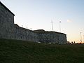
Zobacz też
- Narodowy Pomnik Historyczny USA
- Parki stanowe USA
Bibliografia
- Castle Island (ang.)
Linki zewnętrzne
Media użyte na tej stronie
Autor: Uwe Dedering, Licencja: CC BY-SA 3.0
Location map of the USA (without Hawaii and Alaska).
EquiDistantConicProjection:
Central parallel:
* N: 37.0° N
Central meridian:
* E: 96.0° W
Standard parallels:
* 1: 32.0° N
* 2: 42.0° N
Made with Natural Earth. Free vector and raster map data @ naturalearthdata.com.
Formulas for x and y:
x = 50.0 + 124.03149777329222 * ((1.9694462586094064-({{{2}}}* pi / 180))
      * sin(0.6010514667026994 * ({{{3}}} + 96) * pi / 180))
y = 50.0 + 1.6155950752393982 * 124.03149777329222 * 0.02613325650382181
      - 1.6155950752393982  * 124.03149777329222 *
     (1.3236744353715044  - (1.9694462586094064-({{{2}}}* pi / 180))
      * cos(0.6010514667026994 * ({{{3}}} + 96) * pi / 180))

The flag of Navassa Island is simply the United States flag. It does not have a "local" flag or "unofficial" flag; it is an uninhabited island. The version with a profile view was based on Flags of the World and as a fictional design has no status warranting a place on any Wiki. It was made up by a random person with no connection to the island, it has never flown on the island, and it has never received any sort of recognition or validation by any authority. The person quoted on that page has no authority to bestow a flag, "unofficial" or otherwise, on the island.

(c) Chris Wood, CC BY-SA 4.0
Fort Independence, on Castle Island, in the harbor approaches to Boston, Massachusetts. For more information see the Wikipedia article w:en:Castle Island.
Autor: Alexrk2, Licencja: CC BY 3.0
Location map of Massachusetts, USA

Autor: Midnightdreary, Licencja: CC-BY-SA-3.0
Fort Independence on Castle Island, South Boston.

Autor: Paul Keleher from Mass, US, Licencja: CC BY 2.0
<a href="http://www.nine3.com/MDC/history.html" target="_blank">Fort Independence</a>, Castle Island, South Boston. Quickly appreciated for its strategic location for the protection of Boston from sea attack, the first fortification on Castle Island was an earthwork and three cannon ordered in 1634 by Governor Dudley of Massachusetts Bay Colony.
After the evacuating British destroyed the island's fortifications 1776, the fort was repaired by troops under the command of Lt. Paul Revere.
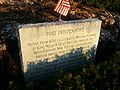
Sign at Fort Independence (Castle Island), Boston, Massachusetts.