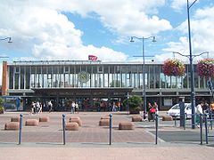
Gare d’Arras
 | |
| Państwo | |
|---|---|
| Region | |
| Miejscowość | |
| Dane techniczne | |
| Liczba peronów | 4 |
| Liczba krawędzi peronowych | 7 |
| Kasy | czynne |
Położenie na mapie Nord-Pas-de-Calais (c) Eric Gaba, Wikimedia Commons user Sting, CC BY-SA 3.0 | |
| Portal | |
Gare d’Arras – stacja kolejowa w Arras, w regionie Hauts-de-France, we Francji. Stacja posiada 4 perony.
Media użyte na tej stronie
France location map-Regions and departements-2016.svg
Autor: Superbenjamin, Licencja: CC BY-SA 4.0
Blank administrative map of France for geo-location purpose, with regions and departements distinguished. Approximate scale : 1:3,000,000
Autor: Superbenjamin, Licencja: CC BY-SA 4.0
Blank administrative map of France for geo-location purpose, with regions and departements distinguished. Approximate scale : 1:3,000,000
Gare d'Arras.JPG
Autor: Florian Pépellin (Floflo), Licencja: CC BY-SA 3.0
Arras, Pas-de-Calais, France - Front of the train station.
Autor: Florian Pépellin (Floflo), Licencja: CC BY-SA 3.0
Arras, Pas-de-Calais, France - Front of the train station.
Nord-Pas-de-Calais region location map.svg
(c) Eric Gaba, Wikimedia Commons user Sting, CC BY-SA 3.0
Blank administrative map of the region of Nord-Pas-de-Calais, France, as in January 2007, for geo-location purpose, with distinct boundaries for regions, departments and arrondissements.
(c) Eric Gaba, Wikimedia Commons user Sting, CC BY-SA 3.0
Blank administrative map of the region of Nord-Pas-de-Calais, France, as in January 2007, for geo-location purpose, with distinct boundaries for regions, departments and arrondissements.
Generic flag of Nord-Pas-de-Calais.svg
Autor: Patricia.fidi, Licencja: CC0
"Lion of Flandres appearing", used on the flag of the Belgian Flanders (located partly in the west of Belgium). It is also sometimes used for French Flanders (western department of northern France). Artois and Hainault (adjacent to this area) have different flags, as well as the Nord-Pas-de-Calais)


