Gonâve (wyspa)
 Wyspa Gonâve widziana z kosmosu, luty 1994 | |
| Kontynent | |
|---|---|
| Państwo | |
| Akwen | |
| Archipelag | |
| Powierzchnia | 743 km² |
| Najwyższy punkt | 778 m n.p.m. |
| 18°50′N 73°05′W/18,833333 -73,083333 | |
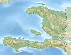
Gonâve – należąca do Haiti wyspa, położona w zatoce Gonâve u zachodnich wybrzeży kraju, na północny zachód od Port-au-Prince.
Zbudowana z wapienia wyspa mierzy ogółem 60 km długości i ok. 15 km szerokości, obejmując powierzchnię 743 km². Wyspa jest otoczona rafą koralową i pokryta niewielkimi pagórkami (najwyższy punkt liczy 778 m n.p.m.). Gleby na wyspie są nieurodzajne i słabo nawodnione, przez co niemożliwa jest tu intensywna uprawa roli. Do największych problemów wyspy należy zaopatrzenie w wodę: rocznie spada tu od 800 do 1600 mm deszczu, źródła wody pitnej są nieliczne i rzadko rozmieszczone.
Ludność wyspy zajmuje się rybołówstwem, hodowlą bydła oraz uprawą bawełny i agawy sizalowej[1].
Niegdyś istniała tu baza piratów morskich.
Przypisy
- ↑ Gonâve, [w:] Encyklopedia PWN [online] [dostęp 2021-04-01].
Media użyte na tej stronie
The national and official state flag of Haiti; arms obtained from http://www.webchantier.com/. The civil flag can be found at here.
Gonave Island, Haiti - February 1994
Located to the west-northwest of Port Au-Prince, Haiti in the Gulf of Gonave, the reef- fringed island of Gonave can be seen in this near-nadir looking view. Made up of mostly limestone, the island of Gonave is 37 miles (60 km) long and 9 miles (15 km) wide and covers an area of 287 sq. miles (743 sq. km). The island is mostly barren and hilly with the highest point reaching 984 feet (300 meters). The rugged, barren, dry landscape prevents the cultivation of the land for agriculture and human population on the island is scarce. The island was once used as a base for pirates.
Autor: Alexrk2, Licencja: CC BY-SA 3.0
Physical Location map Haiti with departements, Equirectangular projection, N/S stretching 105 %. Geographic limits of the map:


