Haymarket Leicester
| ||
 Haymarket | ||
| Państwo | ||
|---|---|---|
| Miejscowość | Leicester | |
| Adres | 1 Kildare Walk, Leicester LE1 3YH | |
| Typ budynku | galeria handlowa | |
| Kondygnacje | 2 | |
| Powierzchnia użytkowa | 23,000 m² | |
| Ukończenie budowy | 1973 | |
Położenie na mapie Leicesteru .svg "Mapa lokalizacyjna Leicesteru") Contains Ordnance Survey data © Crown copyright and database right, CC BY-SA 3.0 | ||
Położenie na mapie Wielkiej Brytanii  (c) Karte: NordNordWest, Lizenz: Creative Commons by-sa-3.0 de | ||
Położenie na mapie Anglii  | ||
Położenie na mapie Leicestershire  Contains Ordnance Survey data © Crown copyright and database right, CC BY-SA 3.0 | ||
| Strona internetowa | ||
Haymarket (ang. Haymarket Shopping Centre) - centrum handlowe położone w centrum miasta Leicester w Wielkiej Brytanii otwarte w 1973 roku. Budynek centrum handlowego znajduje się pomiędzy ulicami Haymarket Street, Belgrave Gate, Charles Street, Humberstone Gate. Obok znajduje się dworzec autobusowy linii miejskich i podmiejskich Hymarket Bus Station. Obok centrum handlowego znajduje się Wieża Zegarowa (Clock Tower). W centrum handlowym znajdują się m.in. Primark, C&A, Tesco Express, TK Maxx, Co-operative, Boots, Clarks, H&M[1]. Wcześniej istniał Haymarket Teatr na poziomie pierwszego piętra, który został zamknięty. Haymarket posiada parking samochodowy na górze centrum handlowego.
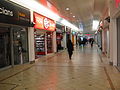
Haymarket w środku

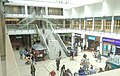
Leicester Haymarket Centre Mall
Po lewej Haymarket
Haymarket w środku
Zobacz też
- Highcross Leicester
- Haymarket Teatr
- Galeria Handlowa St Martin’s Square
Przypisy
- ↑ Haymarket Shopping Centre, Leicester, www.haymarketshoppingcentre.com [dostęp 2017-11-18] (ang.).
Media użyte na tej stronie
(c) Karte: NordNordWest, Lizenz: Creative Commons by-sa-3.0 de
Location map of the United Kingdom


Autor: The oracle 2015, Licencja: CC BY-SA 4.0
A view of the Leicester Haymarket Centre Mall


Autor: NotFromUtrecht, Licencja: CC BY-SA 3.0
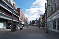
Humberstone Gate in central Leicester
Contains Ordnance Survey data © Crown copyright and database right, CC BY-SA 3.0
Map of Leicester, Leicestershire, UK with electoral wards shown.
Equirectangular map projection on WGS 84 datum, with N/S stretched 160%
Geographic limits:
- West: 1.22W
- East: 1.04W
- North: 52.70N
- South: 52.57N
Contains Ordnance Survey data © Crown copyright and database right, CC BY-SA 3.0
Map of Leicestershire, UK with the following information shown:
- Administrative borders
- Coastline, lakes and rivers
- Roads and railways
- Urban areas
Equirectangular map projection on WGS 84 datum, with N/S stretched 160%
Geographic limits:
- West: 1.80W
- East: 0.50W
- North: 53.00N
- South: 52.36N

Autor: The oracle 2015, Licencja: CC BY-SA 4.0
Haymarket Shopping Centre Mall 2015