Heathrow Terminal 4
 Przejście na stację z budynku terminalu | |
| Państwo | |
|---|---|
| Kraj | |
| Miejscowość | |
| Data otwarcia | 1986 |
| Piccadilly line | |
| Poprzednia stacja | Heathrow Terminals 1, 2, 3 |
| Następna stacja | koniec linii |
Położenie na mapie gminy Hillingdon  Contains Ordnance Survey data © Crown copyright and database right, CC BY-SA 3.0 | |
Położenie na mapie Wielkiej Brytanii  (c) Karte: NordNordWest, Lizenz: Creative Commons by-sa-3.0 de | |
Położenie na mapie Anglii  | |
Położenie na mapie Wielkiego Londynu  Contains Ordnance Survey data © Crown copyright and database right, CC BY-SA 3.0 | |
| Portal | |
Heathrow Terminal 4 – jedna z trzech stacji metra londyńskiego, a ściślej Piccadilly line[1], zlokalizowanych na terenie lotniska Heathrow, największego portu lotniczego w Wielkiej Brytanii. Została otwarta w 1986 roku[2]. Jest stacją końcową dla połowy pociągów metra obsługujących lotnisko (druga połowa kończy bieg na stacji przy terminalu 5). W roku 2008 skorzystało z niej ok. 1,17 mln pasażerów[3]. W systemie londyńskiej komunikacji miejskiej należy do szóstej strefy biletowej[4].
Przy Terminalu 4 na Heathrow znajduje się również stacja kolejowa o takiej samej nazwie, jednak uważana jest za zupełnie odrębny obiekt od stacji metra.
Galeria

Logo stacji

Jeden z peronów
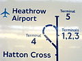
Schemat linii metra na terenie lotniska Heathrow
Przypisy
- ↑ Schemat sieci metra w Londynie [dostęp 2010-12-13]
- ↑ Piccadilly Line w serwisie Clive's UndergrounD Line Guides [dostęp 2010-12-13]
- ↑ Tube performance | Transport for London. [dostęp 2010-12-13].
- ↑ Lista stacji i stref biletowych metra londyńskiego [dostęp 2010-12-13]
| Linia główna |
|
|---|---|
| Odgałęzienie Uxbridge |
|
| Odgałęzienie Heathrow |
|
![]()
Media użyte na tej stronie
(c) Karte: NordNordWest, Lizenz: Creative Commons by-sa-3.0 de
Location map of the United Kingdom
Contains Ordnance Survey data © Crown copyright and database right, CC BY-SA 3.0
Map of Greater London, UK with the following information shown:
- Administrative borders
- Coastline, lakes and rivers
- Roads and railways
- Urban areas
The data includes both primary routes and railway lines.
Equirectangular map projection on WGS 84 datum, with N/S stretched 160%
Geographic limits:
- West: 0.57W
- East: 0.37E
- North: 51.72N
- South: 51.25N


Flag of England. Saint George's cross (a red cross on a white background), used as the Flag of England, the Italian city of Genoa and various other places.

Autor: Mike Knell, Licencja: CC BY-SA 2.0
Symbol londýnského metra a stanice Heathrow Terminal

Autor: Sunil060902, Licencja: CC-BY-SA-3.0
Looking east along the westbound-only platform at Heathrow Terminal 4 tube station
Contains Ordnance Survey data © Crown copyright and database right, CC BY-SA 3.0
Blank map of the London Borough of Hillingdon, showing electoral wards.
Equirectangular map projection on WGS 84 datum, with N/S stretched 160%
Geographic limits:
- West: 0.53W
- East: 0.33W
- North: 51.64N
- South: 51.45N

A diagram of the London Underground Piccadilly Line at Heathrow Airport, including the Terminal 5 extension, open 2008. Photo of a sign at Ealing Common station.

Autor: Sunil060902, Licencja: CC-BY-SA-3.0
Entrance to Heathrow Terminal 4 tube station