Heusenstamm
 | |||
| |||
| Państwo | |||
|---|---|---|---|
| Kraj związkowy | |||
| Zarządzający | Johann Anton Hemberger↗ | ||
| Powierzchnia | 19,03 km² | ||
| Wysokość | 130 m n.p.m. | ||
| Populacja (2015-12-31) • liczba ludności • gęstość |
| ||
| Nr kierunkowy | 06104, 06106 | ||
| Kod pocztowy | 63150 | ||
| Tablice rejestracyjne | OF | ||
 | |||
| Strona internetowa | |||
| Portal | |||
Heusenstamm – miasto w Niemczech, w kraju związkowym Hesja, w rejencji Darmstadt, w powiecie Offenbach.
Współpraca
 Saint-Savin, Francja
 Tonbridge, Wielka Brytania
 Malle, Belgia
 Ladispoli, Włochy
Przypisy
- ↑ Die Bevölkerung in Hessen am 31.12.2015. statistik.hessen.de. [dostęp 2017-02-17]. (niem.).
Media użyte na tej stronie
Autor: NordNordWest, Licencja: CC BY-SA 3.0
Location map of Germany (Wp article: en:Germany)
The flag of the United Kingdom (3:5 version). This flag is the Union Flag in the 3:5 ratio exclusively used on land. At sea, the correct ratio is 1:2.
Autor: Fritz Geller-Grimm, Licencja: CC BY-SA 3.0
Aerial photograph of Heusenstamm, Hessen, Germany
Autor: Hanhil based on work by TUBS, Licencja: CC BY-SA 3.0
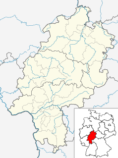
Location map Hesse, showing position of Bavaria within Germany. Geographic limits of the map:


