Hrabstwo Catron
| hrabstwo | |
 | |
| Państwo | |
|---|---|
| Stan | |
| Siedziba | Reserve |
| Powierzchnia | 17 946 km² |
| Populacja (2012) • liczba ludności | 3 6581,8[1] |
Położenie na mapie Nowy Meksyk | |
| 33°54′06,53″N 108°23′31,55″W/33,901814 -108,392097 | |
| Strona internetowa | |
| Portal | |
Hrabstwo Catron – hrabstwo w USA w zachodniej części stanu Nowy Meksyk. Pod względem zajmowanego obszaru największe hrabstwo w tym stanie[2]. W roku 2010 liczba mieszkańców wyniosła 3 725[1].
Wioski
- Reserve
CDP
- Apache Creek
- Aragon
- Cruzville
- Datil
- Escudilla Bonita
- Glenwood
- Homestead
- Lower Frisco
- Luna
- Middle Frisco
- Pie Town
- Pleasanton
- Quemado
- Rancho Grande
- Rivers
Przypisy
- ↑ a b State & County QuickFacts - Catron County, New Mexico (ang.). U.S. Census Bureau. [dostęp 2013-03-20].
- ↑ mylocalgov.com. [dostęp 2007-09-27]. [zarchiwizowane z tego adresu (2007-09-27)].
Media użyte na tej stronie
The flag of Navassa Island is simply the United States flag. It does not have a "local" flag or "unofficial" flag; it is an uninhabited island. The version with a profile view was based on Flags of the World and as a fictional design has no status warranting a place on any Wiki. It was made up by a random person with no connection to the island, it has never flown on the island, and it has never received any sort of recognition or validation by any authority. The person quoted on that page has no authority to bestow a flag, "unofficial" or otherwise, on the island.
Autor: Peter Potrowl, Licencja: CC BY-SA 3.0
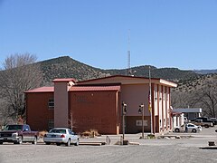
The Catron County Courthouse in Reserve (New Mexico, USA).


