Hrabstwo Cooke
| hrabstwo | |
 Farma wiatrowa Wolf Ridge w Muenster | |
| Państwo | |
|---|---|
| Stan | |
| Siedziba | |
| Data powstania | 1848[1] |
| Powierzchnia | 2266 km² |
| Populacja (2020) • liczba ludności |
|
| • gęstość | 18,4 os./km² |
| Numer kierunkowy | 940 |
| Kod pocztowy | 76233, 76238-41, 76250, 76252, 76253, 7621-73 |
| Strefa czasowa | |
Adres urzędu: 101 South Dixon, Gainesville, Texas 76240 | |
Położenie na mapie Teksas | |
| 33°38′N 97°13′W/33,633333 -97,216667 | |
| Strona internetowa | |
| Portal | |
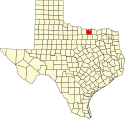
Hrabstwo Cooke – hrabstwo położone w Stanach Zjednoczonych w północnej części stanu Teksas, przy granicy z Oklahomą, od której dzieli je rzeka Red River[2]. Hrabstwo utworzono w 1848 roku poprzez wydzielenie terytorium z hrabstw Fannin Land Distric oraz terytorium niezorganizowanego, jednak ostateczny, obecny kształt uzyskało dopiero w 1857 roku[1]. Siedzibą władz hrabstwa jest jego największe miasto Gainesville, zamieszkałe przez ponad 30% mieszkańców hrabstwa[3].
Nazwa hrabstwa pochodzi od nazwiska Williama G. Cooke, bohatera rewolucji teksańskiej[2].
Sąsiednie hrabstwa
- Hrabstwo Love, Oklahoma (północ)
- Hrabstwo Grayson (wschód)
- Hrabstwo Denton (południe)
- Hrabstwo Wise (południowy zachód)
- Hrabstwo Montague (zachód)
Miasta
- Callisburg
- Gainesville
- Lindsay
- Muenster
- Oak Ridge
- Valley View
CDP
- Lake Kiowa
Główne drogi
Przez teren hrabstwa przebiega autostrada międzystanowa oraz droga krajowa i stanowa:
 Autostrada międzystanowa nr 35
 Droga krajowa 82
 Droga stanowa nr 51
Demografia
W 2020 roku, w hrabstwie 92,0% mieszkańców stanowiła ludność biała (74,4% nie licząc Latynosów), 3,6% to byli czarnoskórzy Amerykanie lub Afroamerykanie, 2,0% miało rasę mieszaną, 1,4% to rdzenna ludność Ameryki, 1,0% to byli Azjaci i 0,08% pochodziło z wysp Pacyfiku. Latynosi stanowili 18,9% ludności hrabstwa[4].
Religia
W krajobrazie religijnym hrabstwa dominują ewangelikalni protestanci i katolicy. W 2010 roku katolicy stanowili 22,7% populacji hrabstwa, to jest kilkakrotnie więcej niż w sąsiednich hrabstwach, a Kościół katolicki jest największym związkiem wyznaniowym[5][6].
Wśród protestantów najwięcej członków posiadali baptyści, ale obecne były także zbory bezdenominacyjne, metodyści, campbellici i wiele mniejszych ugrupowań. Inne religie to głównie: mormoni (1,4%) i świadkowie Jehowy (1 zbór)[5].
Przypisy
- ↑ a b Texas: Individual County Chronologies (ang.). [dostęp 2018-02-01]. [zarchiwizowane z tego adresu (2015-05-13)].
- ↑ a b Robert Wayne McDaniel: Cooke County (ang.). Handbook of Texas Online, Texas State Historical Association. [dostęp 2018-02-03].
- ↑ U.S. Census Bureau QuickFacts: Gainesville city, Texas; Cooke County, Texas, www.census.gov [dostęp 2021-11-19] (ang.).
- ↑ U.S. Census Bureau QuickFacts: Cooke County, Texas; Texas, www.census.gov [dostęp 2022-02-06] (ang.).
- ↑ a b Cooke County (Texas) - Religious Traditions, 2010, www.thearda.com [dostęp 2022-02-06].
- ↑ Catholic Counties (2010) | QuickLists | The Association of Religion Data Archives, www.thearda.com [dostęp 2022-02-06].
Media użyte na tej stronie
The flag of Navassa Island is simply the United States flag. It does not have a "local" flag or "unofficial" flag; it is an uninhabited island. The version with a profile view was based on Flags of the World and as a fictional design has no status warranting a place on any Wiki. It was made up by a random person with no connection to the island, it has never flown on the island, and it has never received any sort of recognition or validation by any authority. The person quoted on that page has no authority to bestow a flag, "unofficial" or otherwise, on the island.
24 in by 24 in (600 mm by 600 mm) Texas State Highway shield, made to the specifications of the sign detail. Uses the Roadgeek 2005 fonts. (United States law does not permit the copyrighting of typeface designs, and the fonts are meant to be copies of a U.S. Government-produced work anyway.) Colors (for Recreation Road shields) are from [1] (Pantone Brown 469), converted to RGB by [2].
Autor: Ben, Licencja: CC BY-SA 2.0
Wolf Ridge Wind Farm in Muenster, Texas
This is a locator map showing Cooke County in Texas. For more information, see Commons:United States county locator maps.
600 mm × 600 mm (24 in × 24 in) U.S. Highway shield, made to the specifications of the 2004 edition of Standard Highway Signs. (Note that there is a missing "J" label on the left side of the diagram.) Uses the Roadgeek 2005 fonts. (United States law does not permit the copyrighting of typeface designs, and the fonts are meant to be copies of a U.S. Government-produced work anyway.)
Autor:
- real name: Artur Jan Fijałkowski
- pl.wiki: WarX
- commons: WarX
- mail: [1]
- jabber: WarX@jabber.org
- irc: [2]
- software: own perl scripts
Piramida wieku dla hrabstwa Cooke w stanie Teksas w USA na podstawie spisu ludności z 2000 roku


