Hrabstwo Dawson (Teksas)
| hrabstwo | |
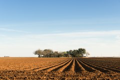 Hrabstwo ma charakter rolniczy | |
| Państwo | |
|---|---|
| Stan | |
| Siedziba | Lamesa |
| Data powstania | 1876[1] |
| Powierzchnia | 2336 km² |
| Populacja (2010) • liczba ludności | 13 833[2] |
| • gęstość | 6,41 os./km² |
| Numer kierunkowy | 806 |
| Kod pocztowy | 79331, 79351, 79377, 79713 |
| Strefa czasowa | UTC-6:00 UTC-5:00 |
Adres urzędu: 400 S 1st Street, Lamesa, Texas 79331 | |
Położenie na mapie Teksas | |
| 32°44′24″N 101°57′00″W/32,740000 -101,950000 | |
| Strona internetowa | |
| Portal | |

Piramida wieku hrabstwa
Hrabstwo Dawson – hrabstwo położone w Stanach Zjednoczonych, w środkowo-zachodniej części stanu Teksas[3]. Hrabstwo utworzono w 1876 roku poprzez wydzielenie terytorium z Young Territory, jednak później podlegało jeszcze zmianom a ostateczny, obecny kształt uzyskało dopiero w 1905 roku[1]r. Siedzibą władz hrabstwa jest największe miasto zamieszkałe przez 8% mieszkańców hrabstwa[2].
Nazwa hrabstwa pochodzi od nazwiska Nicholasa Mosby Dawsona żołnierza w rewolucji teksańskiej poległego w tzw. Masakrze Dawsona (ang. Dawson Massacre)[4][3].
Sąsiednie hrabstwa
- Hrabstwo Lynn (północ)
- Hrabstwo Borden (wschód)
- Hrabstwo Martin (południe)
- Hrabstwo Gaines (zachód)
- Hrabstwo Terry (północny zachód)
- Hrabstwo Andrews (południowy zachód)
- Hrabstwo Borden (południowy wschód)
Miasta
- Ackerly
- Lamesa
- Los Ybanez
- Welch (CDP)
Główne drogi
Przez teren hrabstwa przebiegają między innymi dwie drogi krajowe oraz stanowe:
 U.S. Route 87
 U.S. Route 180
 Droga stanowa nr 83
 Droga stanowa nr 137
Przypisy
- ↑ a b Texas: Individual County Chronologies (ang.). [dostęp 2018-02-08]. [zarchiwizowane z tego adresu (2015-05-13)].
- ↑ a b Population of Dawson County, Texas Population Census 2010 and 2000 (ang.). CensusViewer. [dostęp 2018-02-08].
- ↑ a b Leona M. Gelin and Mark Odintz: Dawson County (ang.). Handbook of Texas Online, Texas State Historical Association. [dostęp 2018-02-08].
- ↑ Charles G. Davis: Dawson,Nicholasa Mosby (ang.). Handbook of Texas Online, Texas State Historical Association. [dostęp 2018-02-08].

Kontrola autorytatywna (hrabstwo w stanie Teksas):
Media użyte na tej stronie

Flag of the United States.svg
The flag of Navassa Island is simply the United States flag. It does not have a "local" flag or "unofficial" flag; it is an uninhabited island. The version with a profile view was based on Flags of the World and as a fictional design has no status warranting a place on any Wiki. It was made up by a random person with no connection to the island, it has never flown on the island, and it has never received any sort of recognition or validation by any authority. The person quoted on that page has no authority to bestow a flag, "unofficial" or otherwise, on the island.
The flag of Navassa Island is simply the United States flag. It does not have a "local" flag or "unofficial" flag; it is an uninhabited island. The version with a profile view was based on Flags of the World and as a fictional design has no status warranting a place on any Wiki. It was made up by a random person with no connection to the island, it has never flown on the island, and it has never received any sort of recognition or validation by any authority. The person quoted on that page has no authority to bestow a flag, "unofficial" or otherwise, on the island.

Deep, rich furrows in farmland east of Lamesa in Dawson County, Texas LCCN2014631713.tif
Title: Deep, rich furrows in farmland east of Lamesa in Dawson County, Texas
Title: Deep, rich furrows in farmland east of Lamesa in Dawson County, Texas
Physical description: 1 photograph : digital, tiff file, color.
Notes: Title, date, and keywords based on information provided by the photographer.; Gift; The Lyda Hill Foundation; 2014; (DLC/PP-2014:054).; Forms part of: Lyda Hill Texas Collection of Photographs in Carol M. Highsmith's America Project in the Carol M. Highsmith Archive.; Credit line: The Lyda Hill Texas Collection of Photographs in Carol M. Highsmith's America Project, Library of Congress, Prints and Photographs Division.

US 180.svg
750 mm × 600 mm (30 in × 24 in) U.S. Highway shield, made to the specifications of the 2004 edition of Standard Highway Signs. (Note that there is a missing "J" label on the left side of the diagram.) Uses the Roadgeek 2005 fonts. (United States law does not permit the copyrighting of typeface designs, and the fonts are meant to be copies of a U.S. Government-produced work anyway.)
750 mm × 600 mm (30 in × 24 in) U.S. Highway shield, made to the specifications of the 2004 edition of Standard Highway Signs. (Note that there is a missing "J" label on the left side of the diagram.) Uses the Roadgeek 2005 fonts. (United States law does not permit the copyrighting of typeface designs, and the fonts are meant to be copies of a U.S. Government-produced work anyway.)

US 87.svg
600 mm × 600 mm (24 in × 24 in) U.S. Highway shield, made to the specifications of the 2004 edition of Standard Highway Signs. (Note that there is a missing "J" label on the left side of the diagram.) Uses the Roadgeek 2005 fonts. (United States law does not permit the copyrighting of typeface designs, and the fonts are meant to be copies of a U.S. Government-produced work anyway.)
600 mm × 600 mm (24 in × 24 in) U.S. Highway shield, made to the specifications of the 2004 edition of Standard Highway Signs. (Note that there is a missing "J" label on the left side of the diagram.) Uses the Roadgeek 2005 fonts. (United States law does not permit the copyrighting of typeface designs, and the fonts are meant to be copies of a U.S. Government-produced work anyway.)
Map of Texas highlighting Dawson County.svg
This is a locator map showing Dawson County in Texas. For more information, see Commons:United States county locator maps.
This is a locator map showing Dawson County in Texas. For more information, see Commons:United States county locator maps.
USA Dawson County, Texas age pyramid.svg
Autor:
Piramida wieku dla hrabstwa Dawson w stanie Teksas w USA na podstawie spisu ludności z 2000 roku
Autor:
- real name: Artur Jan Fijałkowski
- pl.wiki: WarX
- commons: WarX
- mail: [1]
- jabber: WarX@jabber.org
- irc: [2]
- software: own perl scripts
Piramida wieku dla hrabstwa Dawson w stanie Teksas w USA na podstawie spisu ludności z 2000 roku
