Hrabstwo Gray (Teksas)
| hrabstwo | |
 | |
| Państwo | |
|---|---|
| Stan | |
| Siedziba | |
| Powierzchnia | 2407 km² |
| Populacja (2020) • liczba ludności |
|
| • gęstość | 8,8 os./km² |
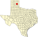
Położenie na mapie Teksas | |
| Strona internetowa | |
| Portal | |
Hrabstwo Gray – hrabstwo położone w USA w stanie Teksas. Utworzone w 1876 r. Siedzibą hrabstwa jest miasto Pampa. Według spisu w 2020 roku populacja spadła do 21,2 tys. mieszkańców[1].
Gospodarka
Jest to przede wszystkim hrabstwo przemysłowo–rolnicze, w którym fundamentalną rolę odgrywają wydobycie ropy naftowej, petrochemia, hodowla bydła, przemysł mleczarski i uprawa bawełny, ale także znaczący wkład mają trzoda chlewa, uprawa pszenicy, produkcja paszy i hodowla koni[2][3].
Sąsiednie hrabstwa
- Hrabstwo Roberts (północ)
- Hrabstwo Wheeler (wschód)
- Hrabstwo Donley (południe)
- Hrabstwo Carson (zachód)
- Hrabstwo Hemphill (północny wschód)
- Hrabstwo Hutchinson (północny zachód)
- Hrabstwo Collingsworth (południowy wschód)
Miasta
- Lefors
- McLean
- Pampa
Demografia
W 2020 roku 89,8% mieszkańców hrabstwa stanowiła ludność biała (62,0% nie licząc Latynosów), 5,6% to byli czarnoskórzy Amerykanie lub Afroamerykanie, 2,2% miało rasę mieszaną, 1,6% to rdzenna ludność Ameryki i 0,7% to byli Azjaci. Latynosi stanowili 29,8% ludności hrabstwa[1].
Religia
W 2010 roku większość mieszkańców to ewangelikalni protestanci, następnie byli katolicy (10,5%) i mormoni (1,8%)[4].
Przypisy
- ↑ a b U.S. Census Bureau QuickFacts: Gray County, Texas; Texas, www.census.gov [dostęp 2022-02-11] (ang.).
- ↑ TSHA | Gray County, www.tshaonline.org [dostęp 2022-02-11].
- ↑ Census of Agriculture - 2017 Census Publications - State and County Profiles - Texas, www.nass.usda.gov [dostęp 2022-02-11].
- ↑ Gray County (Texas) - Religious Traditions, 2010, www.thearda.com [dostęp 2022-02-11].
Media użyte na tej stronie
The flag of Navassa Island is simply the United States flag. It does not have a "local" flag or "unofficial" flag; it is an uninhabited island. The version with a profile view was based on Flags of the World and as a fictional design has no status warranting a place on any Wiki. It was made up by a random person with no connection to the island, it has never flown on the island, and it has never received any sort of recognition or validation by any authority. The person quoted on that page has no authority to bestow a flag, "unofficial" or otherwise, on the island.
Autor:
- real name: Artur Jan Fijałkowski
- pl.wiki: WarX
- commons: WarX
- mail: [1]
- jabber: WarX@jabber.org
- irc: [2]
- software: own perl scripts
Piramida wieku dla hrabstwa Gray w stanie Teksas w USA na podstawie spisu ludności z 2000 roku
This is a locator map showing Gray County in Texas. For more information, see Commons:United States county locator maps.
This image or file is a work of a United States Department of Agriculture employee, taken or made as part of that person's official duties. As a work of the U.S. federal government, the image is in the public domain.


