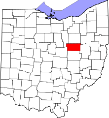
Hrabstwo Holmes (Ohio)
| hrabstwo | |
 | |
| Państwo | |
|---|---|
| Stan | |
| Siedziba | Millersburg |
| Kod statystyczny | FIPS 6-4: 39075 |
| Powierzchnia | 1 098,21 km²[1] |
| Populacja (2010) • liczba ludności |
|
| • gęstość | 38,67 os./km² |
| Strefa czasowa | UTC-5/-4 |
Położenie na mapie Ohio | |
| 40°33′40,24″N 81°55′44,37″W/40,561178 -81,928992 | |
| Portal | |
Hrabstwo Holmes (ang. Holmes County) – hrabstwo w stanie Ohio w Stanach Zjednoczonych. Obszar całkowity hrabstwa obejmuje powierzchnię 424,02 mil2 (1 098,21 km²). Według danych z 2010 r. hrabstwo miało 42 366 mieszkańców[2]. Hrabstwo powstało 20 stycznia 1824 roku i nosi imię Andrew Holmesa, oficera amerykańskiej armii poległego w wojnie 1812 roku.
Hrabstwo jest domem dla drugiej co do wielkości społeczności amiszów, którą w 2017 roku oszacowano na ponad 35 tysięcy[3].
Sąsiednie hrabstwa
- Hrabstwo Wayne (północ)
- Hrabstwo Stark (północny wschód)
- Hrabstwo Tuscarawas (wschód)
- Hrabstwo Coshocton (południe)
- Hrabstwo Knox (południowy zachód)
- Hrabstwo Ashland (północny zachód)
CDP
- Berlin
- Lake Buckhorn
- Walnut Creek
- Winesburg
Wioski
- Baltic
- Glenmont
- Holmesville
- Killbuck
- Loudonville
- Millersburg
- Nashville
Linki zewnętrzne
- American FactFinder (ang.). [dostęp 2012-03-25]. [zarchiwizowane z tego adresu (2019-05-21)].
Przypisy
- ↑ Census 2000 U.S. Gazetteer Files: Counties (ang.). [dostęp 2012-05-11].
- ↑ QuickFacts from the US Census Bureau (ang.). [dostęp 2012-06-06].
- ↑ The 12 Largest Amish Communities (2017), amishamerica.com [dostęp 2020-06-26].
Media użyte na tej stronie
The flag of Navassa Island is simply the United States flag. It does not have a "local" flag or "unofficial" flag; it is an uninhabited island. The version with a profile view was based on Flags of the World and as a fictional design has no status warranting a place on any Wiki. It was made up by a random person with no connection to the island, it has never flown on the island, and it has never received any sort of recognition or validation by any authority. The person quoted on that page has no authority to bestow a flag, "unofficial" or otherwise, on the island.
This is a locator map showing Holmes County in Ohio. For more information, see Commons:United States county locator maps.
Autor: Alvintrusty, Licencja: CC BY-SA 4.0
Holmes County Ohio, Court House


