Hrabstwo Tyler (Teksas)
| hrabstwo | |
(c) Larry D. Moore, CC BY-SA 3.0 | |
| Państwo | |
|---|---|
| Stan | |
| Siedziba | Woodville |
| Powierzchnia | 2 424,23 km² |
| Populacja (2000) • liczba ludności | 20 871 |
| • gęstość | 8,61 os./km² |
Położenie na mapie Teksas | |
| Strona internetowa | |
| Portal | |
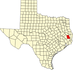
Hrabstwo Tyler – hrabstwo położone w USA w stanie Teksas z siedzibą w mieście Woodville. Utworzone w 1846 r.
Demografia
Według spisu z roku 2000, hrabstwo zamieszkuje 20 871 osób, które tworzą 7775 gospodarstw domowych oraz 5675 rodzin. 84,0% ludności hrabstwa to ludzie biali, 12,0% to czarni, 0,4% rdzenni Amerykanie, 0,2% Azjaci, 0,02% mieszkańcy z wysp Pacyfiku, 2,5% ludność innych ras, 1,1% ludność wywodząca się z dwóch lub większej liczby ras, 3,6% to osoby hiszpańskojęzyczne lub Latynosi.
W hrabstwie znajduje się 7775 gospodarstw domowych, z czego w 29,7% z nich znajdują się dzieci poniżej 18 roku życia. Średnia wielkość gospodarstwa domowego 2,5 osoby, a średnia wielkość rodziny to 2,9 osoby.
Wśród mieszkańców hrabstwa 23,2% stanowią osoby poniżej 18 lat, 8,0% osoby z przedziału wiekowego 18-24 lat, 27,2% osoby w wieku od 25 do 44 lat, 23,8% w wieku 45-64 lat i 17,8% osoby, które mają 65 lub więcej lat. Średni wiek wynosi 39 lat. Na każde 100 kobiet przypada 106,9 mężczyzn, a na każde 100 kobiet mających lat 18 lub więcej przypada 108,2 mężczyzn.
Średni roczny dochód w hrabstwie dla gospodarstwa domowego wynosi 29 808 $, a średni roczny dochód dla rodziny to 35 195 $. Średni dochód mężczyzny to 31 797 $, kobiety 19 594 $. Średni roczny dochód na osobę wynosi 15 367 $. 12,6% rodzin i 15.8%% mieszkańców hrabstwa żyje poniżej minimum socjalnego, z czego 21,0% to osoby poniżej 18 lat a 10,1% to osoby powyżej 65 roku życia.
Sąsiednie hrabstwa
- Hrabstwo Angelina (północ)
- Hrabstwo Jasper (wschód)
- Hrabstwo Hardin (południe)
- Hrabstwo Polk (zachód)
Miasta
- Chester
- Colmesneil
- Ivanhoe
- Ivanhoe North
- Woodville
CDP
- Warren
Drogi główne
 U.S. Highway 69
 U.S. Highway 190
 U.S. Highway 287
Media użyte na tej stronie
The flag of Navassa Island is simply the United States flag. It does not have a "local" flag or "unofficial" flag; it is an uninhabited island. The version with a profile view was based on Flags of the World and as a fictional design has no status warranting a place on any Wiki. It was made up by a random person with no connection to the island, it has never flown on the island, and it has never received any sort of recognition or validation by any authority. The person quoted on that page has no authority to bestow a flag, "unofficial" or otherwise, on the island.
(c) Larry D. Moore, CC BY-SA 3.0
The Tyler County Courthouse in Woodville, Texas, United States. The courthouse was designated a Recorded Texas Historic Landmark in 2000
750 mm × 600 mm (30 in × 24 in) U.S. Highway shield, made to the specifications of the 2004 edition of Standard Highway Signs. (Note that there is a missing "J" label on the left side of the diagram.) Uses the Roadgeek 2005 fonts. (United States law does not permit the copyrighting of typeface designs, and the fonts are meant to be copies of a U.S. Government-produced work anyway.)
600 mm × 600 mm (24 in × 24 in) U.S. Highway shield, made to the specifications of the 2004 edition of Standard Highway Signs. (Note that there is a missing "J" label on the left side of the diagram.) Uses the Roadgeek 2005 fonts. (United States law does not permit the copyrighting of typeface designs, and the fonts are meant to be copies of a U.S. Government-produced work anyway.)
750 mm × 600 mm (30 in × 24 in) U.S. Highway shield, made to the specifications of the 2004 edition of Standard Highway Signs. (Note that there is a missing "J" label on the left side of the diagram.) Uses the Roadgeek 2005 fonts. (United States law does not permit the copyrighting of typeface designs, and the fonts are meant to be copies of a U.S. Government-produced work anyway.)
This is a locator map showing Tyler County in Texas. For more information, see Commons:United States county locator maps.
Autor:
- real name: Artur Jan Fijałkowski
- pl.wiki: WarX
- commons: WarX
- mail: [1]
- jabber: WarX@jabber.org
- irc: [2]
- software: own perl scripts
Piramida wieku dla hrabstwa Tyler w stanie Teksas w USA na podstawie spisu ludności z 2000 roku


