Hrabstwo Val Verde
| hrabstwo | |
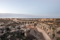 Mosty nad wąwozem w hrabstwie Val Verde | |
| Państwo | |
|---|---|
| Stan | |
| Siedziba | Del Rio |
| Powierzchnia | 8372 km² |
| Populacja (2020) • liczba ludności | 47 586 |
| • gęstość | 5,8 os./km² |
Położenie na mapie Teksas | |
| Portal | |

Piramida wieku hrabstwa
Hrabstwo Val Verde – hrabstwo położone w południowo zachodnim Teksasie, w Stanach Zjednoczonych, na granicy z Meksykiem. Utworzone w 1885 r. Siedzibą hrabstwa jest miasto Del Rio. Według spisu w 2020 roku hrabstwo liczy 47,6 tys. mieszkańców, w tym 82,3% to Latynosi[1].
Hrabstwo Val Verde posiada jedno z największych stad kóz w Stanach Zjednoczonych (35,4 tys. w 2017 roku[2]), oraz drugie co do wielkości stado owiec w Teksasie (39,5 tys. w 2017 roku[3])[4].
Sąsiednie hrabstwa
- Hrabstwo Crockett (północ)
- Hrabstwo Sutton (północny wschód)
- Hrabstwo Edwards (wschód)
- Hrabstwo Kinney (wschód)
- Hrabstwo Terrell (zachód)
- Gmina Acuña, Coahuila, Meksyk (południe)
- Gmina Jiménez, Coahuila, Meksyk (południe)
Miasta
CDP
- Amistad
- Box Canyon
- Cienegas Terrace
- Lake View
- Val Verde Park
Przypisy
- ↑ U.S. Census Bureau QuickFacts: Val Verde County, Texas; Texas, www.census.gov [dostęp 2022-02-08] (ang.).
- ↑ Texas - Table 17. Meat Goats and Other Goats - Inventory and Sales: 2017 and 2012, nass.usda.gov [dostęp 2022-02-08].
- ↑ Texas - Table 13. Sheep and Lambs - Inventory, Sales, and Wool Production: 2017 and 2012, nass.usda.gov [dostęp 2022-02-08].
- ↑ Map: Do you live in Sheeplandia or Goatopia?, „Washington Post”, ISSN 0190-8286 [dostęp 2022-02-08] (ang.).

Kontrola autorytatywna (hrabstwo w stanie Teksas):
Media użyte na tej stronie

Flag of the United States.svg
The flag of Navassa Island is simply the United States flag. It does not have a "local" flag or "unofficial" flag; it is an uninhabited island. The version with a profile view was based on Flags of the World and as a fictional design has no status warranting a place on any Wiki. It was made up by a random person with no connection to the island, it has never flown on the island, and it has never received any sort of recognition or validation by any authority. The person quoted on that page has no authority to bestow a flag, "unofficial" or otherwise, on the island.
The flag of Navassa Island is simply the United States flag. It does not have a "local" flag or "unofficial" flag; it is an uninhabited island. The version with a profile view was based on Flags of the World and as a fictional design has no status warranting a place on any Wiki. It was made up by a random person with no connection to the island, it has never flown on the island, and it has never received any sort of recognition or validation by any authority. The person quoted on that page has no authority to bestow a flag, "unofficial" or otherwise, on the island.

Bridges over a deep gully in Val Verde County in southwest Texas LCCN2014631249.tif
Title: Bridges over a deep gully in Val Verde County in southwest Texas
Title: Bridges over a deep gully in Val Verde County in southwest Texas
Physical description: 1 photograph : digital, tiff file, color.
Notes: Title, date, and keywords based on information provided by the photographer.; Gift; The Lyda Hill Foundation; 2014; (DLC/PP-2014:054).; Forms part of: Lyda Hill Texas Collection of Photographs in Carol M. Highsmith's America Project in the Carol M. Highsmith Archive.; Credit line: The Lyda Hill Texas Collection of Photographs in Carol M. Highsmith's America Project, Library of Congress, Prints and Photographs Division.
USA Val Verde County, Texas age pyramid.svg
Autor:
Piramida wieku dla hrabstwa Val Verde w stanie Teksas w USA na podstawie spisu ludności z 2000 roku
Autor:
- real name: Artur Jan Fijałkowski
- pl.wiki: WarX
- commons: WarX
- mail: [1]
- jabber: WarX@jabber.org
- irc: [2]
- software: own perl scripts
Piramida wieku dla hrabstwa Val Verde w stanie Teksas w USA na podstawie spisu ludności z 2000 roku
Map of Texas highlighting Val Verde County.svg
This is a locator map showing Val Verde County in Texas. For more information, see Commons:United States county locator maps.
This is a locator map showing Val Verde County in Texas. For more information, see Commons:United States county locator maps.