Hrabstwo Washington (Maryland)
| hrabstwo | |||
 | |||
| |||
| Państwo | |||
|---|---|---|---|
| Stan | |||
| Siedziba | |||
| Kod statystyczny | FIPS 6-4: 24043 | ||
| Powierzchnia | 1 210,95 km² | ||
| Populacja (2000) • liczba ludności |
| ||
| • gęstość | 111,2 os./km² | ||
| Strefa czasowa | UTC -5:00/-4:00 | ||
Położenie na mapie Maryland | |||
| Strona internetowa | |||
| Portal | |||
Hrabstwo Washington (ang. Washington County) to hrabstwo w amerykańskim stanie Maryland. Hrabstwo zajmuje powierzchnię 1 210,95 km² i według szacunków US Census Bureau w roku 2006 liczyło 143 748 mieszkańców. Siedzibą hrabstwa jest miasto Hagerstown.
Historia

Hrabstwo Washington powstało w roku 1776, w wyniku podziału hrabstwa Frederick na trzy mniejsze hrabstwa. Hrabstwo zostało nazwane na cześć George'a Washingtona, naczelnego dowódcy Armii Kontynentalnej podczas wojny o niepodległość Stanów Zjednoczonych, który został później pierwszym prezydentem Stanów Zjednoczonych. W 1789 roku hrabstwo Washington uległo zmniejszeniu, gdy z jego części utworzono hrabstwo Allegany.
Geografia
Całkowita powierzchnia hrabstwa wynosi 1 210,95 km², z czego 1 186,58 km² stanowi powierzchnia lądowa, a 24,37 km² (2,0%) powierzchnia wodna. Najwyższym punktem w hrabstwie jest szczyt góry Quirauk, który wznosi się na wysokość 652 m n.p.m., zaś najniższy punkt o wysokości 76 m n.p.m. znajduje się na rzece Potomak, w pobliżu miasta Harpers Ferry.
W hrabstwie znajduje się sześć parków stanowych.
Miasta
- Boonsboro
- Clear Spring
- Funkstown
- Hagerstown
- Hancock
- Keedysville
- Sharpsburg
- Smithsburg
- Williamsport
CDP
- Antietam
- Bagtown
- Bakersville
- Beaver Creek
- Big Pool
- Big Spring
- Breathedsville
- Brownsville
- Cavetown
- Cearfoss
- Charlton
- Chewsville
- Dargan
- Downsville
- Eakles Mill
- Edgemont
- Ernstville
- Fairplay
- Fairview
- Fort Ritchie
- Fountainhead-Orchard Hills
- Gapland
- Garretts Mill
- Greensburg
- Halfway
- Highfield-Cascade
- Indian Springs
- Jugtown
- Kemps Mill
- Leitersburg
- Mapleville
- Mercersville
- Middleburg
- Maugansville
- Mount Aetna
- Mount Briar
- Mount Lena
- Paramount-Long Meadow
- Pecktonville
- Pinesburg
- Pondsville
- Reid
- Ringgold
- Sandy Hook
- Robinwood
- Rohrersville
- St. James
- San Mar
- Tilghmanton
- Trego-Rohrersville Station
- Wilson-Conococheague
- Yarrowsburg
Demografia
Według szacunków US Census Bureau w roku 2006 hrabstwo Washington liczyło 143 748 mieszkańców.
Bibliografia
- Podstawowe dane statystyczne o hrabstwie Washington US Census Bureau (en)
- Podstawowe dane statystyczne dotyczące hrabstw w stanie Maryland US Census Bureau (en)
- Najniżej i najwyżej położone punkty w hrabstwach w Maryland. mgs.md.gov. [zarchiwizowane z tego adresu (2014-01-03)]. Maryland Geological Survey (en)
- Profil hrabstwa Washington Maryland State Archives (en)
Media użyte na tej stronie
The flag of Navassa Island is simply the United States flag. It does not have a "local" flag or "unofficial" flag; it is an uninhabited island. The version with a profile view was based on Flags of the World and as a fictional design has no status warranting a place on any Wiki. It was made up by a random person with no connection to the island, it has never flown on the island, and it has never received any sort of recognition or validation by any authority. The person quoted on that page has no authority to bestow a flag, "unofficial" or otherwise, on the island.
Autor:
- real name: Artur Jan Fijałkowski
- pl.wiki: WarX
- commons: WarX
- mail: [1]
- jabber: WarX@jabber.org
- irc: [2]
- software: own perl scripts
Piramida wieku dla hrabstwa Washington w stanie Maryland w USA na podstawie spisu ludności z 2000 roku
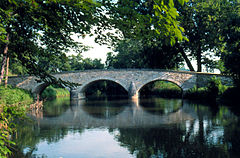
Burnside's Bridge, Sharpsburg, MD, was named after Union General Ambrose Burnside who commanded the Ninth Corps at Antietam, Battle of Antietam - September 17, 1862. His soldiers made repeated attacks against the small force of Confederates who defended this crucial Antietam Creek crossing.
This is a locator map showing Washington County in Maryland. For more information, see Commons:United States county locator maps.


