Kennington (Londyn)
| ||||
| ||||
 (c) R Sones, CC BY-SA 2.0 Widok na Kennington Park Road | ||||
| Państwo | ||||
| Kraj | ||||
| Region | Wielki Londyn | |||
| Miasto | Londyn | |||
| Gmina | Lambeth | |||
| Kod pocztowy | SE11 | |||
Położenie na mapie Wielkiego Londynu  Contains Ordnance Survey data © Crown copyright and database right, CC BY-SA 3.0 | ||||
Położenie na mapie Wielkiej Brytanii  (c) Karte: NordNordWest, Lizenz: Creative Commons by-sa-3.0 de | ||||
Położenie na mapie Anglii  | ||||
| 51°28′53″N 0°07′11″W/51,481300 -0,119700 | ||||
| Portal | ||||
Kennington – dzielnica południowego Londynu, część gminy Lambeth[1], położona w odległości 3,8 km od centrum Londynu (Charing Cross)[2]. Kennington jest wspomniana w Domesday Book (1086) jako Chenintune[3]. Posiada kod pocztowy SE11. Według stanu na rok 2011, dzielnicę zamieszkiwało nieco ponad 21 tys. ludzi.
W okolicy położony jest stadion krykietowy The Oval, a na terenie Brandon Estate znajduje się jedna z rzeźb Henry'ego Moore'a.[4]
Znane osoby
- William Blake, poeta i malarz
- James Callaghan, premier brytyjski
- Charlie Chaplin, aktor
- Eliza Cook, pisarka
- Karen Gillan, aktorka
- William Hogarth, malarz
- David Laws, polityk
- Don Letts, reżyser i muzyk
- Bob Marley, muzyk, pomieszkiwał na St. Agnes Place w latach 70.[5]
- Edith Nesbit, pisarka
- David Ricardo, ekonomista polityczny
- Kevin Spacey, aktor
- Vincent van Gogh, malarz, mieszkał w Ivy Cottage na 395 Kennington Road w latach 1874-1875
- Sarah Waters, pisarka
Galeria
Od lewej: Stacja metra Kennington, Kennington Park, Durning Library, Ethelred Estate, Kennington Road.
 (c) Stacey Harris, CC BY-SA 2.0
 (c) Stephen McKay, CC BY-SA 2.0
 (c) Derek Harper, CC BY-SA 2.0
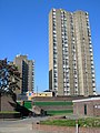 (c) Danny Robinson, CC BY-SA 2.0
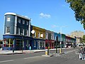 (c) Danny Robinson, CC BY-SA 2.0
Przypisy
- ↑ Please refine your search (ang.). Geograph (Ordnance Survey). [dostęp 2016-09-10].
- ↑ Distance from KENNINGTON [TQ312776] (ang.). GENUKI. [dostęp 2016-09-10].
- ↑ Surrey (ang.). The Domesday Book online. [dostęp 2016-09-10].
- ↑ Area guide for Kennington (ang.). www.kfh.co.uk. [dostęp 2018-09-15].
- ↑ Door slams on London's longest-running squat (ang.). www.telegraph.co.uk, 2005-11-30. [dostęp 2017-07-15].
Media użyte na tej stronie
Contains Ordnance Survey data © Crown copyright and database right, CC BY-SA 3.0
Map of Greater London, UK with the following information shown:
- Administrative borders
- Coastline, lakes and rivers
- Roads and railways
- Urban areas
The data includes both primary routes and railway lines.
Equirectangular map projection on WGS 84 datum, with N/S stretched 160%
Geographic limits:
- West: 0.57W
- East: 0.37E
- North: 51.72N
- South: 51.25N
(c) Karte: NordNordWest, Lizenz: Creative Commons by-sa-3.0 de
Location map of the United Kingdom


Flag of England. Saint George's cross (a red cross on a white background), used as the Flag of England, the Italian city of Genoa and various other places.

(c) Stacey Harris, CC BY-SA 2.0
Kennington Underground Station

(c) Danny Robinson, CC BY-SA 2.0
Brightly Coloured Shops at Kennington Cross. These shops are on Kennington Road, between Windmill Row and Kennington Lane. In the background is the Ethelred Estate 575945
_-_geograph.org.uk_-_575945.jpg)

(c) Derek Harper, CC BY-SA 2.0
Durning Library, Kennington. Housed in a flamboyant Victorian building on Kennington Lane.
_-_geograph.org.uk_-_575945.jpg)
(c) Danny Robinson, CC BY-SA 2.0
Ethelred Estate, Kennington (2) The concrete sections used to build the tower blocks can clearly be seen in this picture.

(c) Stephen McKay, CC BY-SA 2.0
Kennington Park Kennington Park was originally common land, but was laid out as a park in the mid-19th century. In the 17th and 18th centuries it was the site of public executions and in 1848 a major chartist rally was held here which led directly to a change in the law extending the franchise in 1852. During the Second World War a communal shallow-trench air raid shelter was built here which suffered a direct hit in October 1940 killing at least 46 people. The full story of this terrible event is told here: http://www.vauxhallandkennington.org.uk/forgottentragedy.pdf .
(c) R Sones, CC BY-SA 2.0
Kennington Marker and Kennington Park Road, London SE11