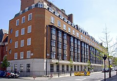
King Edward VII’s Hospital Sister Agnes
| ||
 | ||
| Nazwa angielska | King Edward VII’s Hospital Sister Agnes | |
| Data założenia | 1899 | |
| Typ szpitala | szpital prywatny | |
| Państwo | ||
| Kraj | ||
| Adres | Beaumont Street, London England, W1G 6AA | |
| Dyrektor | John Lofthouse | |
| Łóżka szpitalne | 58 | |
Położenie na mapie City of Westminster Contains Ordnance Survey data © Crown copyright and database right, CC BY-SA 3.0 | ||
Położenie na mapie Wielkiej Brytanii (c) Karte: NordNordWest, Lizenz: Creative Commons by-sa-3.0 de | ||
Położenie na mapie Wielkiego Londynu Contains Ordnance Survey data © Crown copyright and database right, CC BY-SA 3.0 | ||
| Strona internetowa | ||
King Edward VII’s Hospital Sister Agnes – prywatna placówka medyczna funkcjonująca w Londynie, w dzielnicy Marylebone. Szpital został założony w 1899 roku przez Agnes Keyser – metresę księcia Walii, a późniejszego króla Edwarda VII – oraz jej siostrę Fanny. Początkowo był przeznaczony dla chorych i rannych brytyjskich żołnierzy, którzy wrócili z wojny burskiej. Sponsorem i pierwszym patronem szpitala był król Edward VII. Obecnie (2016) działa pod patronatem królowej Elżbiety II[1][2].
Pacjentami szpitala Króla Edwarda VII są członkowie brytyjskiej rodziny królewskiej. Na przestrzeni lat byli tutaj hospitalizowani: Elżbieta II, księżniczka Małgorzata, Elżbieta – Królowa Matka, Filip, książę Edynburga, Karol, książę Walii, a w grudniu 2012 roku Katarzyna, księżna Cambridge[3].
Przypisy
- ↑ James Meikle. King Edward VII hospital – the royal choice. „The Guardian”, 2012-12-07 (ang.).
- ↑ KING EDWARD VII’s HOSPITAL Sister Agnes (ang.). kingedwardvii.co.uk. [dostęp 2012-12-12].
- ↑ Kate admitted to hospital with royal connections (ang.). itv.com, 2012-12-04. [dostęp 2012-12-26].
Media użyte na tej stronie
(c) Karte: NordNordWest, Lizenz: Creative Commons by-sa-3.0 de
Location map of the United Kingdom
Contains Ordnance Survey data © Crown copyright and database right, CC BY-SA 3.0
Map of Greater London, UK with the following information shown:
- Administrative borders
- Coastline, lakes and rivers
- Roads and railways
- Urban areas
The data includes both primary routes and railway lines.
Equirectangular map projection on WGS 84 datum, with N/S stretched 160%
Geographic limits:
- West: 0.57W
- East: 0.37E
- North: 51.72N
- South: 51.25N
Flag of England. Saint George's cross (a red cross on a white background), used as the Flag of England, the Italian city of Genoa and various other places.
medical icon for maps. hospital with emergency and beds
Contains Ordnance Survey data © Crown copyright and database right, CC BY-SA 3.0
Blank map of the City of Westminster, showing electoral wards.
Equirectangular map projection on WGS 84 datum, with N/S stretched 160%
Geographic limits:
- West: 0.22W
- East: 0.1W
- North: 51.55N
- South: 51.48N
Autor: Jacek Plewa, Licencja: CC BY 3.0
King Edward VII's Hospital Sister Agnes; London


