Knaresborough
| ||
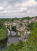
 Rzeka Nidd przepływająca przez Knaresborough | ||
| Państwo | ||
| Kraj | ||
| Region | Yorkshire and The Humber | |
| Hrabstwo | North Yorkshire | |
| Dystrykt | Harrogate | |
| Populacja (2011) • liczba ludności | 15 441 | |
| Nr kierunkowy | 01423 | |
| Kod pocztowy | HG5 | |
Położenie na mapie North Yorkshire Contains Ordnance Survey data © Crown copyright and database right, CC BY-SA 3.0 | ||
Położenie na mapie Wielkiej Brytanii (c) Karte: NordNordWest, Lizenz: Creative Commons by-sa-3.0 de | ||
| Strona internetowa | ||
| Portal | ||
Knaresborough – miasto i civil parish w Wielkiej Brytanii, w Anglii, w regionie Yorkshire and the Humber, w hrabstwie North Yorkshire, w dystrykcie Harrogate[1]. Leży 4,1 km od miasta Harrogate, 25,9 km od miasta York i 293,2 km od Londynu[2], nad rzeką Nidd. W 2011 roku civil parish liczyła 15 441 mieszkańców[3]. Knaresborough jest wspomniana w Domesday Book (1086) jako Chenaresburg[4].
W tym mieście ma siedzibę klub piłkarski – Knaresborough Town F.C.
Przypisy
- ↑ Knaresborough (ang.). Ordnance Survey linked data. [dostęp 2016-04-27].
- ↑ Distance from KNARESBOROUGH [SE350575] (ang.). GENUKI. [dostęp 2016-04-27].
- ↑ Area: Knaresborough (Parish) (ang.). Neighbourhood Statistics (ONS). [dostęp 2016-04-27]. [zarchiwizowane z tego adresu (2016-10-05)].
- ↑ Place name: Knaresborough, Yorkshire (ang.). The Domesday Book online. [dostęp 2016-04-27].
Media użyte na tej stronie
(c) Karte: NordNordWest, Lizenz: Creative Commons by-sa-3.0 de
Location map of the United Kingdom
Flag of England. Saint George's cross (a red cross on a white background), used as the Flag of England, the Italian city of Genoa and various other places.
Contains Ordnance Survey data © Crown copyright and database right, CC BY-SA 3.0
Map of North Yorkshire, UK with the following information shown:
- Administrative borders
- Coastline, lakes and rivers
- Roads and railways
- Urban areas
Equirectangular map projection on WGS 84 datum, with N/S stretched 170%
Geographic limits:
- West: 2.60W
- East: 0.10W
- North: 54.67N
- South: 53.60N
Autor: Oryginalnym przesyłającym był Markdarb z angielskiej Wikipedii, Licencja: CC BY 2.0
A famous view of the Knaresborough Viaduct across the River Nidd. The Church of St John the Baptist can be seen in the background, obscured by trees. This photo is taken from the hill after which the town is named, the site of the ruins of Knaresborough Castle (borough derives from an Old English word meaning ‘fortress’).


