Lech (gmina)
| |||
 | |||
| |||
| Państwo | |||
|---|---|---|---|
| Kraj związkowy | |||
| Powiat | Bludenz | ||
| Powierzchnia | 89,97 km² | ||
| Wysokość | 1444 m n.p.m. | ||
| Populacja (1 stycznia 2015) • liczba ludności | 1530 | ||
| • gęstość | 17 os./km² | ||
| Numer kierunkowy | 05583 | ||
| Kod pocztowy | 6764 | ||
| Tablice rejestracyjne | BZ | ||
Położenie na mapie Vorarlberga  | |||
Położenie na mapie Austrii  | |||
| Strona internetowa | |||
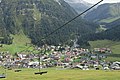
Lech – gmina w Austrii położona w kraju związkowym Vorarlberg, w powiecie Bludenz. Leży na granicy Alp Algawskich i pasma Lechquellengebirge. Jest znaną bazą narciarską i ośrodkiem sportowym. W skład gminy wchodzi łącznie 14 miejscowości. Liczy 1530 mieszkańców (1 stycznia 2015)[1].
Galeria
Lech latem

Kościół pw. św. Mikołaja (St Nikolaus)

Lech zimą
Współpraca
Miejscowości partnerskie:
 Beaver Creek Resort, Stany Zjednoczone
 Hakuba, Japonia
 Kampen (Sylt), Niemcy
Linki zewnętrzne
Przypisy
Media użyte na tej stronie
Austria Vorarlberg location map.svg
Autor: Rosso Robot, Licencja: CC BY-SA 3.0
Location map of Vorarlberg
Autor: Rosso Robot, Licencja: CC BY-SA 3.0
Location map of Vorarlberg
Equirectangular projection. Geographic limits of the map:
- N: 47.62 N
- S: 46.82 N
- W: 9.45 E
- E: 10.3 E
Austria location map.svg
Autor: Lencer, Licencja: CC BY-SA 3.0
Location map of Austria
Autor: Lencer, Licencja: CC BY-SA 3.0
Location map of Austria
Equirectangular projection, N/S stretching 150 %. Geographic limits of the map:
- N: 49.2° N
- S: 46.3° N
- W: 9.4° E
- E: 17.2° E


Flag of the United States.svg
The flag of Navassa Island is simply the United States flag. It does not have a "local" flag or "unofficial" flag; it is an uninhabited island. The version with a profile view was based on Flags of the World and as a fictional design has no status warranting a place on any Wiki. It was made up by a random person with no connection to the island, it has never flown on the island, and it has never received any sort of recognition or validation by any authority. The person quoted on that page has no authority to bestow a flag, "unofficial" or otherwise, on the island.
The flag of Navassa Island is simply the United States flag. It does not have a "local" flag or "unofficial" flag; it is an uninhabited island. The version with a profile view was based on Flags of the World and as a fictional design has no status warranting a place on any Wiki. It was made up by a random person with no connection to the island, it has never flown on the island, and it has never received any sort of recognition or validation by any authority. The person quoted on that page has no authority to bestow a flag, "unofficial" or otherwise, on the island.


GemeindeLech.JPG
Autor: --Böhringer böhringer friedrich, Licencja: CC BY-SA 2.5
Ortsteil von Lech am Arlberg.
Autor: --Böhringer böhringer friedrich, Licencja: CC BY-SA 2.5
Ortsteil von Lech am Arlberg.

AUT Lech COA.png
Lech, Vorarlberg: Ein silberner Wellenbalken spaltet Blau von Rot. Im vorderen blauen Feld eine goldene Sonne, im hinteren roten Feld auf schwarzem Dreiberg eine schwarze Tanne.
Lech, Vorarlberg: Ein silberner Wellenbalken spaltet Blau von Rot. Im vorderen blauen Feld eine goldene Sonne, im hinteren roten Feld auf schwarzem Dreiberg eine schwarze Tanne.
Lech am Arlberg 2006.jpg
Autor: Florian Lindner, Licencja: CC BY 2.5
Omeshorn (2557 m) rechts, südlich über Lech am Arlberg im Lechquellengebirge in Vorarlberg, links des Omeshorns führt das Tal des Zürsbaches nach Zürs und weiter zum Flexenpass, ganz links der Rüfikopf.
Autor: Florian Lindner, Licencja: CC BY 2.5
Omeshorn (2557 m) rechts, südlich über Lech am Arlberg im Lechquellengebirge in Vorarlberg, links des Omeshorns führt das Tal des Zürsbaches nach Zürs und weiter zum Flexenpass, ganz links der Rüfikopf.

Lech Dorfkirche.jpg
Autor: Florian Lindner, Licencja: CC BY 2.5
Dorfkirche in Lech am Arlberg, selbst fotografiert
Autor: Florian Lindner, Licencja: CC BY 2.5
| Pozycja obiektu |
|
To i inne zdjęcia na: OpenStreetMap |
|
|---|
